Galleria Umberto I

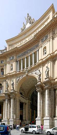
Galleria Umberto I is a public shopping gallery in Naples, southern Italy. It is located directly across from the San Carlo opera house. It was built between 1887–1891, and was the cornerstone in the decades-long rebuilding of Naples — called the risanamento (lit. "making healthy again") — that lasted until World War I. It was designed by Emanuele Rocco, who employed modern architectural elements reminiscent of the Galleria Vittorio Emanuele II in Milan. The Galleria was named for Umberto I, King of Italy at the time of construction. It was meant to combine businesses, shops, cafes and social life — public space — with private space in the apartments on the third floor.[1][2]
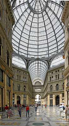
The Galleria is a high and spacious cross-shaped structure, surmounted by a glass dome braced by 16 metal ribs. Of the four iron and glass-vaulted wings, one fronts on via Toledo (via Roma), still the main downtown thoroughfare, and another opens onto the San Carlo Theater. It has returned to being an active center of Neapolitan civic life after years of decay.[1][2] The building is part of the UNESCO listing of the Historic Centre of Naples as a World Heritage Site.[3]
The Galleria Umberto is the setting for The Gallery (1947) by the American writer John Horne Burns (1916–1953) based on his experiences as an American soldier in Naples shortly after the liberation of the city.[1]
_-_n._1135_-_Napoli_-_Galleria_Umberto_I.jpg)
Galleria Umberto I around 1900 
Interior Galleria Umberto I 
Detail of one Wing 
Detail of the Floor 
Galleria Umberto I from top 
Interior of Galleria Umberto I. Naples, Campania, Italy, Southern Europe
References
- 1 2 3 Ugo Carughi. La galleria Umberto I. Architettura del ferro a Napoli. Di Mauro, 1996. ISBN 8885263860.
- 1 2 Renato De Fusco. Facciamo finta che: cronistoria architettonica e urbanistica di Napoli in scritti critici e polemici dagli anni '50 al 2000. Liguori Editore Srl, 2004. ISBN 8820737140.
- ↑ Valentina Castellano Chiodo (5 December 2013). "Top10 Patrimonio Unesco Italia: Napoli e i gioielli del centro storico". Corriere della Sera (Dove). Retrieved 25 May 2016.
External links
| Wikimedia Commons has media related to Galleria Umberto I (Naples). |
Coordinates: 40°50′19.06″N 14°14′58.45″E / 40.8386278°N 14.2495694°E