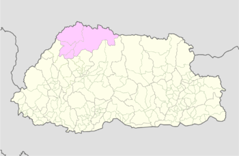
Gasa District
| Gasa | |
|---|---|
| Dzongkhag | |
 | |
| Coordinates: 28°0′N 90°0′E / 28.000°N 90.000°ECoordinates: 28°0′N 90°0′E / 28.000°N 90.000°E | |
| Country |
|
| Capital | Gasa Dzong |
| Area[1] | |
| • Total | 3,117.74 km2 (1,203.77 sq mi) |
| Highest elevation[1] | 4,500 m (14,800 ft) |
| Lowest elevation[1] | 1,500 m (4,900 ft) |
| Population (2005)[1] | |
| • Total | 3,116 |
| • Estimate (2010) | 3,396 |
| • Density | 1.00/km2 (2.6/sq mi) |
| Time zone | BTT (UTC+6) |
| • Summer (DST) | not observed (UTC+6) |

Gasa District or Gasa Dzongkhag (Dzongkha: མགར་ས་རྫོང་ཁག་; Wylie: Mgar-sa rdzong-khag) is one of the 20 dzongkhags (districts) comprising Bhutan. The northern part of Gasa District is a disputed zone under the control of the People`s Republic of China. The capital of Gasa District is Gasa Dzong near Gasa. It is located in the far north of the county and spans the Middle and High regions of the Tibetan Himalayas. The dominant language of the district is Dzongkha, which is the national language. Related languages, Layakha and Lunanakha, are spoken by semi-nomadic communities in the north of the district.
Gasa has an area of 3,117.74 km2 (1,203.77 sq mi) as of 2010,[1] formerly 4,409.30 km2 (1,702.44 sq mi) as of 2002.<ref "dop.gov.bt 2002">
"Gasa Dzongkhag Ninth Plan (2002-2007)" (PDF). Department of Planning, Ministry of Finance, Royal Government of Bhutan. 2002. Archived from the original (PDF) on 16 August 2005. External link in |publisher= (help)
</ref> It had a population of 3,116 as of the 2005 census,[1] making it the largest, least populated, and thus least densely populated of all the dzongkhags; it is also the least developed.
History
Gasa was formerly a drungkhag (sub-district) of the Punakha dzongkhag (district). It became a separate dzongkhag in 1992, the start of 7th Five Year Plan.[1]
Administrative divisions
Gasa District is divided into four village blocks (or gewogs):[1][2]
- Khamaed Gewog,[2] formerly known as ⋅Goenkhamae[1]
- Khatoed Gewog,[2] formerly known as Goenkaatoe[1]
- Laya Gewog[1][2]
- Lunana Gewog[1][2]
Geography
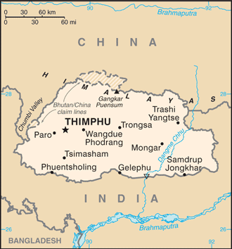
Gasa is bordered to the north by Tibet Autonomous Region of the People's Republic of China and by Thimphu, Punakha, and Wangdue Phodrang dzongkhags to the south.
Economy
Gasa has become a tourist destination because of its pristine forests and the exceptionally scenic location of its Dzong. In 2008 a massive flood on the Mo Chhu (Female River) destroyed a popular hot spring complex, which is under restoration and was to re-open in late 2011. The high altitude makes farming difficult, although government programs seek to establish mustard and summer vegetable planting programs. Residents herd yaks and dzos, and a small number benefit from the nascent tourism industry. A narrow road from Punakha, which is mostly unpaved, reaches up to the Dzong and is now being extended up to Laya. The majority of the known herds of wild Takin occur in Gasa. Electricity is also being supplied to some of the gewogs and all electrification programmes are expected to be complete by 2012.
Gasa is most famous for its Layap people, and for the Snowman Trek, one of the most challenging treks in the Himalayas.
Environment
All of Gasa is an environmentally protected area of Bhutan. Most of the dzongkhag lies within Jigme Dorji National Park (Khamaed, Khatoed, Laya, Lunana Gewogs), although the northeast reaches of Gasa are part of Wangchuck Centennial Park (Lunana Gewog).[3][4] Several of Bhutan's glaciers are located in Gasa, namely in Lunana Gewog, which borders Tibet.
References
- 1 2 3 4 5 6 7 8 9 10 11 12 "Annual Dzongkhag Statistics 2010: Gasa" (PDF). National Statistics Bureau, Government of Bhutan. 2010. Retrieved 22 August 2011. External link in
|publisher=(help) - 1 2 3 4 5 "Gewogs and chiwogs in Gasa (2011)" (PDF). Election Commission, Government of Bhutan. 2011. Retrieved 28 July 2011. External link in
|publisher=(help) - ↑ "Parks of Bhutan". Bhutan Trust Fund for Environmental Conservation online. Bhutan Trust Fund. Retrieved 26 March 2011.
- ↑ "Chiwogs in Gasa" (PDF). Election Commission, Government of Bhutan. 2011. Retrieved 2011-07-28.
See also
| Central | ||
|---|---|---|
| Southern | ||
| Western | ||
| Eastern | ||