Gettys-Black divide
| Gettys-Black divide | |
|---|---|
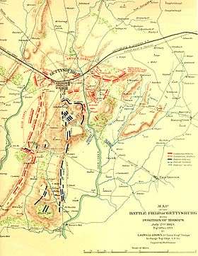 The northern part of the divide is roughly along a Union line (blue) during the Battle of Gettysburg (the map inaccurately depicts Big Round Top west of Plum Run). | |
| Highest point | |
| Peak | Big Round Top (north slope) |
| Elevation | |
| Coordinates | 39°47′10.73″N 77°14′21.15″W / 39.7863139°N 77.2392083°W |
| Naming | |
| Etymology | Gettys Tavern & Black's Mill |
| Geography | |
| Location | northern point (confluence of Stevens Cr/Rock Cr) |
| Country | United States |
| State | Pennsylvania |
| County | Adams |
| Range coordinates | 39°50′13″N 77°13′17″W / 39.8369°N 77.2215°WCoordinates: 39°50′13″N 77°13′17″W / 39.8369°N 77.2215°W |
The Gettys-Black divide is the primary drainage divide of Cumberland Township, Adams County, Pennsylvania; extending from the mouth of Stevens Creek southward past Samuel Gettys' 1761 tavern ~7 miles to the mouth of Plum Run at the dam site for Robert Black's 1798 Mill.[1] From a ridge within the Gettysburg borough, the divide extends southward across several strategic features of the Gettysburg Battlefield:
- Cemetery Hill (503 ft)
- Cemetery Ridge, including the triple point for Plum R/Stevens Cr (west) & Rock Cr (east)
- Weikert Hill
- Little Round Top
- Big Round Top
The divide descends the east slope of Big Round Top and passes north of a drainage, then extends south-southeast across farm fields near the Taneytown Road to Rock Creek at the unincorporated community of Barlow, Pennsylvania.
References
- ↑ Geiselman, John P. (1996). "Horner's Mill Becomes Barlow". In Cleveland, Linda K. Reflections. Preface: Audrey J. Sanders. Columbus GA: Brentwood Christian Press. p. 55. Retrieved 2010-05-04.
This article is issued from Wikipedia - version of the 7/28/2013. The text is available under the Creative Commons Attribution/Share Alike but additional terms may apply for the media files.