Rujm el-Hiri
|
رُجم الهِرّي גלגל רפאים | |
 Rujm el-Hiri – Gilgal Refaim | |
 Shown within Golan Heights | |
| Alternate name | Rogem Hiri, Galgal Refaim |
|---|---|
| Location | Golan Heights |
| Coordinates | 32°54′31″N 35°48′03″E / 32.908705°N 35.800705°E |
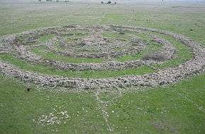
Rujm el-Hiri (Arabic: رجم الهري, Rujm al-Hīrī; Hebrew: גִּלְגַּל רְפָאִים Gilgal Refā'īm or Rogem Hiri) is an ancient megalithic monument, consisting of concentric circles of stone with a tumulus at center.[1] It is located in the Israeli-occupied portion of the Golan Heights, some 16 kilometers east of the coast of the Sea of Galilee, in the middle of a large plateau covered with hundreds of dolmen.[1][2]
Made up of more than 42,000 basalt rocks arranged in concentric circles, it has a mound 15 feet (4.6 m) tall at its center.[2] Some circles are complete, others incomplete. The outermost wall is 520 feet (160 m) in diameter and 8 feet (2.4 m) high. The establishment of the site, and other nearby ancient settlements, is dated by archaeologists to the Early Bronze Age II period (3000–2700 BCE).[1]
The site is believed to be an ancient observatory and stellar calendar.[3] Since excavations have yielded very few material remains, Israeli archeologists theorize that the site was not a defensive position or a residential quarter but most likely a ritual center, possibly linked to the cult of the dead.[4] However, there is no consensus regarding its function, as no similar structure has been found in the Near East.[5]
Etymology
The name Rujm el-Hiri, "stone heap of the wild cat",[2] appears on Syrian maps.[6] The term rujm in Arabic (pl. rujum; Hebrew: rogem) can also refer to a tumulus, a heap of stones underneath which human burial space was located.[1] The name is sometimes romanized as Rujm Hiri or Rujum al-Hiri.
Rogem Hiri is a Hebrew version of the Arabic name Rujm el-Hiri.[2] A modern name used for the site is Gilgal Refā'īm or Galgal Refā'īm, "Wheel of Spirits" or "Wheel of Ghosts" as Refa'im in modern Hebrew means "ghosts" or "spirits". The same root underlies the word used in the Tanakh to refer to a race of giants, the Rephaites, described as the ancient people of Bashan (modern Golan).[7][8]
Structure and description
The site's size and location, on a wide plateau which is also scattered with hundreds of dolmens, means that an aerial perspective is necessary to see the complete layout.[1] The site was made from Basalt rocks, common in the Golan Heights due to the region's history of volcanic activity. It is made from 37,500 - 40,000[9] tons of partly worked stone stacked up to 2 meters (6.6 ft) high.[10] It was estimated by Freikman that the transportation and building of the massive monument would have required more than 25,000 working days.[9] The site is often referred to as the "Stonehenge of the Levant."[11]
The remains consist of a large circle (slightly oval) of basalt rocks, containing four smaller concentric circles, each getting progressively thinner; some are complete, others incomplete.[12] The walls of the circles are connected by irregularly placed smaller stone walls perpendicular to the circles.[12]
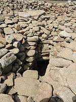
The central tumulus is built from smaller rocks, and is thought to have been constructed after the surrounding walls were constructed.[10] Connecting to it are four main stone walls. The first wall, shaped like a semicircle, is 50m in diameter and 1.5m wide. That wall is connected to a second one, an almost complete circle 90m in diameter. The third wall is a full circle, 110m in diameter and 2.6m wide. The fourth and outermost wall is the largest: 150m in diameter and 3.2m wide.
A central tumulus 65 feet (20 m) in diameter and 15 feet (4.6 m) high is surrounded by concentric circles, the outermost of which is 520 feet (160 m) in diameter and 8 feet (2.4 m) high.[1] Two entrances to the site face the northeast (29 meters (95 ft) wide) and southeast (26 meters (85 ft) wide).[1][2] The northeast entrance leads to an accessway 20 feet (6.1 m) long leading to the center of the circle which seems to point in the general direction of the June solstice sunrise.[2][10] The axis of the tomb discovered at the site's center is similarly aligned.[10] Mount Hermon is almost due north and Mount Tabor is close to December solstice sunrise. Geometry and astronomy are visually connected by the temple's design.[12]
History and purpose
The site was cataloged during an archaeological survey carried out in 1967-1968 by Shmarya Gutman and Claire Epstein.[1] The site is probably the source of the legends about "a remnant of the giants" or Rephaim for Og.[13] The surveyors used Syrian maps, and a Syrian triangulation post was found on top of its cairn.[6] After this initial study, serious archaeological excavations commenced in the 1980s under Israeli professors Moshe Kochavi and Yoni Mizrachi, as part of the Land of Geshur Archaeological Project.[14][15]
Hypotheses
- Worship - According to this hypothesis, the site was used for special ceremonies during the longest and shortest days of the year. It seems, that in the year 3000 BCE, on the longest day, the first rays of the sun shone through the opening in the north-east gate, which is 20 by 29 meters. However, they did not shine in a perfect angle. It is assumed this is because the builders did not have sufficiently accurate architectural tools. The residents probably used the site to worship Tammuz and Ishtar, the gods of fertility,[10] to thank them for the good harvest during the year. After the erection of the tomb in the center, the rays' path was blocked.
- Burial site - It appears that the place of worship later became a burial site[12] for leaders or other important individuals. Supporting this theory was the tomb in the Dolman. However, no human remains were found, only objects pointing to its function as a tomb. Also, even if it were a tomb, that was not the site's original function, as the tomb is 1,000 years newer than the site itself.
- Dakhma – Archaeologist Rami Arav suggests the site was used like the Dakhmas of the Zoroastrians, in which dead persons were laid out for birds to remove the flesh from their bones.[8]
- Calendar - Some believe the site was used as an ancient calendar. At the times of the two equinoxes, the sun's rays would pass between two rocks, 2m in height, 5m in width, at the eastern edge of the compound. According to Anthony Aveni and Yonatan Mizrachi the entrance to the center opens on sunrise of the summer solstice. Other notches in the walls indicate the spring and fall equinoxes.[16]
- Astronomical observations - Perhaps the site was used for astronomical observations of the constellations, probably for religious calculations. Researchers found the site was built with dimensions and scales common for other period structures, and partly based on the stars' positions.[17]
Today
In 2007, the site was excavated by Yosef Garfinkel and Michael Freikman of the Hebrew University of Jerusalem. Freikman returned in the summer of 2010 for further investigation of the site's date and function.[18] Freikman believes that the tomb in the center was built at the same time as the rings. Tomb robbers looted the remains, which included jewelry and weapons, but based on the discovery of one Chalcolithic pin dropped in a passageway, Freikman's theory is that the tomb was the centerpiece of the rings.[19]
New Age movements advocating a return to nature gather at the site on the summer solstice and on the equinox to view the first rays of the sun shine though the rocks.
The Golan Trail, a marked 130-kilometer walking trail that stretches along the whole length of the Golan Heights, passes Gilgal Refa'im.[20]

See also
- Anak
- Excarnation
- Atlit Yam, which contains a semi-circle of megaliths—a possible 2nd "Stonehenge of the Levant," but submerged today—with a 6270BCE~6700BCE destruction date.
- Syro-Palestinian archaeology
References
- 1 2 3 4 5 6 7 8 Avraham Negev; Shimon Gibson (July 2005). Archaeological encyclopedia of the Holy Land. Continuum International Publishing Group. pp. 207, 443, 518. ISBN 978-0-8264-8571-7. Retrieved 30 March 2011.
- 1 2 3 4 5 6 Jerome Murphy-O'Connor (28 February 2008). The Holy Land:An Oxford Archaeological Guide from Earliest Times to 1700. Oxford University Press. p. 531. ISBN 978-0-19-164766-6. Retrieved 9 September 2013.
- ↑ The Genius of Ancient Man: Evolution's Nightmare, Don Landis
- ↑ Grisly theory for Holy Land mystery
- ↑ Rogem Hiri: A Megalithic Monument in the Golan, Mattanyah Zohar, Hebrew University of Jerusalem
- 1 2 Israel. Miśrad ha-ḥinukh ṿeha-tarbut. Dept. of Antiquities and Museums; Universiṭah ha-ʻIvrit bi-Yerushalayim. Makhon le-arkheʾologyah; Ḥevrah la-ḥaḳirat Erets-Yiśraʾel ṿe-ʻatiḳoteha (1996). Israel exploration journal. Israel Exploration Society. p. 194. Retrieved 30 March 2011.
- ↑ "Rogem Hiri - Ancient Mysterious Construction". Israeli Ministry of Foreign Affairs. Retrieved 2009-08-24.
- 1 2 "In the wildcat's pile of stones". Ha'aretz. Retrieved 2009-08-24.
- 1 2 Freikman, M. (2012). "A Near Eastern Megalithic Monument in Context". Journal for Ancient Studes (3): 143–147. External link in
|journal=(help) - 1 2 3 4 5 Anthony F. Aveni (2001). Skywatchers. University of Texas Press. pp. 323–324. ISBN 978-0-292-70502-9. Retrieved 30 March 2011.
- ↑ What's in a (wine's) name, Washington Jewish Week
- 1 2 3 4 Clive L. N. Ruggles (2005). Ancient astronomy: an encyclopedia of cosmologies and myth. ABC-CLIO. pp. 366–368. ISBN 978-1-85109-477-6. Retrieved 29 March 2011.
- ↑ Astronomy in Israel: From Og's Circle to the Wise Observatory, Yuval Ne'eman, Tel Aviv University
- ↑ Kochavi, Moshe; Renner, Timothy; Spar, Ira; Yadlin, Esther (July–August 1992). "Rediscovered! The Land of Geshur". Biblical Archaeology Review. 18 (4). Retrieved 6 April 2013.
- ↑ Rosenberg, Stephen Gabriel (12 March 2009). "The wheel of giants". The Jerusalem Post. Retrieved 6 April 2013.
- ↑ Ancient Archaeoastronomy in the Golan Heights
- ↑ Ancient Astronomy at Rujm el-Hiri: Star Watching in Ancient Israel
- ↑ Rujm el Hiri, Israel – Find a dig
- ↑ Brit-Am Megalithic Bulletin Update
- ↑ Hiking tour: The Golan Trail
Bibliography
- Aveni, Anthony F. (2001). Skywatchers (2nd, revised, illustrated ed.). University of Texas Press. ISBN 978-0-292-70502-9.
- Aveni, Anthony; Mizrachi, Yonathan (1998). "The Geometry and Astronomy of Rujm el-Hiri, a Megalithic Site in the Southern Levant". eTopoi Journal of Field Archaeology. Maney Publishing. 25 (4): 475–496(22). doi:10.1179/009346998792005261.
- Israel Exploration Society; Miśrad ha-ḥinukh ṿeha-tarbut. Dept. of Antiquities and Museums, Ḥevrah la-ḥaḳirat Erets-Yiśraʾel ṿe-ʻatiḳoteha (1996). "Israel exploration journal". 46 (3-4). Israel Exploration Society.
- Murphy-O'Connor, Jerome (2008). The Holy Land: an Oxford archaeological guide from earliest times to 1700 (5th, illustrated ed.). Oxford University Press US. ISBN 978-0-19-923666-4.
- Negev, Avraham; Gibson, Shimon (2005). Archaeological encyclopedia of the Holy Land (4th, revised, illustrated ed.). Continuum International Publishing Group. ISBN 978-0-8264-8571-7.
- Ruggles, Clive L. N. (2005). Ancient astronomy: an encyclopedia of cosmologies and myth (Illustrated ed.). ABC-CLIO. ISBN 978-1-85109-477-6.
Further reading
- Kochavi, M. (1989). "The Land of Geshur Project: Regional Archaeology of Southern Golan (1987–1988)". Israel Exploration Journal (39): 1–9.
External links
| Wikimedia Commons has media related to Rujm el-Hiri. |
- Following Nature's Signpoints, Geographical magazine
- The wheel of giants, Jerusalem post
- GoogleEarth placemark of Rujem el-Hiri Monument