Glarus Alps
| Glarus Alps | |
|---|---|
| Glarner Alpen | |
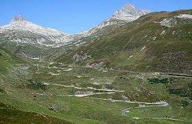
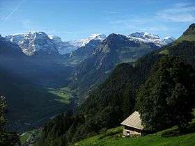 Glarus Alps from Braunwald | |
| Highest point | |
| Peak | Tödi |
| Elevation | 3,614 m (11,857 ft) |
| Coordinates | 46°48′40″N 8°54′53″E / 46.81111°N 8.91472°E |
| Geography | |
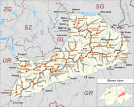 | |
| Country | Switzerland |
| Cantons | Glarus, Uri, Graubünden and St Gallen |
| Range coordinates | 46°56′N 8°55′E / 46.93°N 8.92°ECoordinates: 46°56′N 8°55′E / 46.93°N 8.92°E |
| Parent range | Western Alps |
| Borders on | |
| Topo map | Swiss Federal Office of Topography swisstopo |
| Geology | |
| Orogeny | Alpine orogeny |
The Glarus Alps (German: Glarner Alpen) are a mountain range in central Switzerland. They are bordered by the Uri Alps and the Schwyz Alps to the west, the Lepontine Alps to the south, the Appenzell Alps to the northeast. The eastern part of the Glarus Alps contains a major thrust fault which was declared a geologic UNESCO world heritage site (the Swiss Tectonic Arena Sardona).
The Glarus Alps extend well beyond the canton of Glarus, including parts of the cantons of Uri, Graubünden, and St Gallen. Conversely, not all the mountains in the canton of Glarus are part of the Glarus Alps, with those to the north of the Urner Boden and to the west of the valley of the river Linth considered to be part of the Schwyz Alps.
Geography

The main chain of the Glarus Alps can be divided into six minor groups, separated from each other by passes, the lowest of which exceeds 7,500 ft. The westernmost of these is the Crispalt, a rugged range including many peaks of nearly equal height. The highest of these are the Piz Giuv (3,096 m) and Piz Nair. The name Crispalt is given to a southern, but secondary, peak of Piz Giuv, measuring 3,070 m. West of the main group is the Rienzenstock, while a northern outlyer culminates in the Bristen. East of the Crispalt, the Kreuzli or Chrüxli Pass separates this from the rather higher mass of the Oberalpstock (3,328 m).[1]
Here occurs a partial break in the continuity of the chain. The crest of the snowy range connecting the Oberalpstock with the Tödi nowhere sinks to 9,000 feet, but makes a sweep convex to the north, forming a semicircular recess, whose numerous torrents are all poured into the Rhine through the Val Russein below Disentis. Two glacier passes lead over this part of the chain — one to west, over the Brunnigletscher to the Maderanertal; the other to the north-east, over the Sand Glacier, to the Linthal.[1]
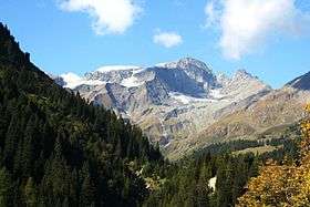
The Tödi, the highest of the range and of north-eastern Switzerland (3,614 m), is attended by numerous secondary peaks that arise from the extensive snow-fields surrounding the central mountain. A very considerable outlyer, whose chief summits are the Schärhorn and the Gross Windgällen, belonging to the canton of Uri, is connected with the Tödi by the range of the Clariden Grat, north to the Hüfi Glacier. A less important branch encloses the Biferten Glacier, and terminates in the Selbsanft, south of Tierfehd. Towards the valley of the Vorderrhein a high promontory stretches nearly due south from the central peaks of the Tödi, and is crowned by the summit of the Piz Posta Biala. Another considerable ramification of the same mass terminates farther to the east in the peak of the Cavistrau.[1]
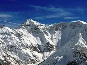
The Kisten Pass separates the Tödi group from the Hausstock, whose summit attains 3,158 m; a branch of this latter group forms the range of the Kärpf in the canton of Glarus. The Hausstock is cut off from the rather lower but more extended mass of the Vorab by the Panixer Pass (7,907 ft). Numerous summits, of which the Vorab proper and Piz Grisch are the most important, approach very near, but do not quite attain to 10,000 feet.[1]
The eastern limit of the latter group is marked by the Segnas Pass — the most frequented of those connecting the Canton Glarus with the Vorderrhein — beyond which arises a wide-stretching mass of rock and glacier, which is part of the Glarus thrust and culminates at Piz Sardona. This mass is cleft by a deep valley — the Calfeisental: one branch, culminating in the Pizol (2,844 m), extends east over Pfäfers, while another, including the highest peak of the canton of St. Gallen, the Ringelspitz (3,247 m), runs due east to the low Kunkels Pass (1,357 m), separating this range from the Calanda.[1]
Principal summits


| Name | Metres | Feet |
|---|---|---|
| Tödi | 3614 | 11,857 |
| Bifertenstock | 3426 | 11,241 |
| Piz Urlaun | 3371 | 11,060 |
| Oberalpstock | 3330 | 10,926 |
| Gross Schärhorn | 3296 | 10,814 |
| Claridenstock | 3270 | 10,729 |
| Düssi | 3256 | 10,703 |
| Ringelspitz | 3251 | 10,667 |
| Cavistrau | 3250 | 10,663 |
| Gross Windgällen | 3192 | 10,473 |
| Hausstock | 3152 | 10,342 |
| Gross Ruchen | 3136 | 10,289 |
| Ruchi | 3107 | 10,194 |
| Piz Segnas | 3102 | 10,178 |
| Piz Giuv | 3098 | 10,165 |
| Schiben | 3084 | 10,118 |
| Crispalt | 3080 | 10,105 |
| Bristen | 3074 | 10,086 |
| Selbsanft | 3029 | 9,938 |
| Bündner Vorab | 3025 | 9,925 |
| Piz Ner | 2859 | 9,380 |
| Tschingelhörner | 2850 | 9,351 |
| Piz Sol Grauehorner | 2849 | 9,348 |
| Calanda | 2808 | 9,213 |
| Kärpf | 2797 | 9,177 |
| Piz Alpetta | 2764 | 9,068 |
| Piz Dado | 2699 | 8,855 |
| Magerrain | 2528 | 8,294 |
| Mürtschenstock | 2442 | 8,012 |
Glaciers
Main glaciers :
Passes
The chief passes of the Tödi Range, from the Oberalp Pass to the Klausen Pass, are:
- Note: road status as of 1911.
| Mountain pass | Location | Type (as of 1911) | Elevation | |
|---|---|---|---|---|
| Clariden Pass | Amsteg to Linthal | snow | 2969 meters | 9741 feet |
| Planura Pass | Amsteg to Linthal | snow | 2940 meters | 9646 feet |
| Kammlilucke or Scheerjoch | Maderanertal to Unterschächen | snow | 2848 meters | 9344 feet |
| Sardona Pass | Flims to Bad Ragaz | snow | 2840 meters | 9318 feet |
| Sand Alp Pass | Disentis to Linthal | snow | 2780 meters | 9121 feet |
| Brunni Pass | Disentis to Amsteg | snow | 2736 meters | 8977 feet |
| Segnes Pass | Elm to Flims | foot path | 2625 meters | 8613 feet |
| Kisten Pass | Linthal to Ilanz | bad bridle path | 2500 meters | 8203 feet |
| Panixer Pass | Elm to Ilanz | bad bridle path | 2407 meters | 7897 feet |
| Chrüzli Pass | Amsteg to Sedrun | foot path | 2350 meters | 7710 feet |
| Foo or Ramin Pass | Elm to Weisstannen | bridle path | 2222 meters | 7290 feet |
| Oberalp Pass | Andermatt to Disentis | carriage road | 2048 meters | 6719 feet |
| Klausen Pass | Altdorf to Linthal | carriage road | 1952 meters | 6404 feet |
See also
References
 This article incorporates text from a publication now in the public domain: Chisholm, Hugh, ed. (1911). "article name needed". Encyclopædia Britannica (11th ed.). Cambridge University Press.
- Swisstopo maps
Maps
- Swiss official cartography (Swiss Federal Office of Topography - Swisstopo); on-line version: map.geo.admin.ch
External links
-
 Media related to Glarus Alps at Wikimedia Commons
 - The Glarus Alps on SummitPost