Glenville, Cleveland
| Glenville | |
|---|---|
| Neighborhoods of Cleveland | |
|
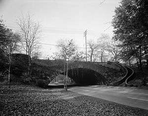
Rockefeller Park with its historic bridges form much of Glenville's western border. | |
| Country | United States |
| State | Ohio |
| County | Cuyahoga County |
| City | Cleveland |
| Population (2000) | |
| • Total | 23,559 |
| 8.8% decrease from 1990 Census | |
| Demographics | |
| • White | 1.2% |
| • Black | 97.4% |
| • Hispanic | >1% |
| • Asian | >1% |
| • Other | >1% |
| Time zone | EST (UTC-5) |
| • Summer (DST) | EDT (UTC-4) |
| ZIP Codes | 44108 |
| Area code(s) | 216 |
| Median income | $21,686 |
| Source: 2000 U.S. Census, City Planning Commission of Cleveland [1] | |
Glenville is a neighborhood on the east side of Cleveland, Ohio. The neighborhood has an irregular border. It begins in the northeast at Eddy Road, and follows Hazeldell Road, E. 110th Street, and Lakeview Road south to E. 114th Street. It follows E. 114th Street South to Superior Avenue, where the border moves east to E. 125th Street. It follows E. 125th Street south to Hower Avenue, and then cuts across residential blocks in a due-south line to Wade Park Avenue. It roughly follows Wade Park Avenue west to E. 105th Street, then E. 105th Street north to Superior Avenue. It follows Superior Avenue west to E. 98th Street. The border follows Parkgate Avenue west, cuts across Rockefeller Park to Crumb Avenue, and then follows Crumb Avenue, E. 79th Street, and St. Clair Avenue to E. 72nd Street. After following E. 72nd Street north to the Lake Erie shore, it follows the shore to encompass the Cleveland Lakefront Nature Preserve before moving due south inland to the Cleveland Memorial Shoreway. The border then follows the Shoreway to Eddy Road.
History
The Glenville neighborhood was founded in 1870 and was later annexed to the City of Cleveland in 1905. Glenville had been a small village, serving mainly as a resort community to Cleveland's upper-middle class residents, just beyond the eastern edge of the city limits.[2] From a period beginning shortly after its annexation and into the 1940s, Glenville was predominantly a Jewish neighborhood with a small African American population.[3] Since the 1960s, racial integration saw an accompanying civil unrest in the neighborhood, which reached its climax in the 1968 Glenville Shootout. Like much of the violence associated with civil unrest during the Civil Rights movement in other major US cities, as well as in the adjacent Hough neighborhood, racial tensions were a catalyst for an ensuing demographic shift.[4] Today, Glenville is predominantly African-American. While having been for over a half century, one of Cleveland's most visible examples of poverty, crime and urban decay, Glenville has in the early 21st century, gained more positive national media attention, particularly in its high school football team, which has rapidly become one of the better known preparatory programs in Ohio as well as the nation.[5][6]
Education
Glenville High School and its feeder schools serve the community at large.
Parks
Glenville is bordered on the northwest by Gordon Park (part of the Cleveland Lakefront State Park district)[7] and on the entirety of its immediate western edge by the winding Rockefeller Park. Built on land donated to the city by John D. Rockefeller in 1897, the wooded 276 acres, through which a section of Martin Luther King Drive runs, is known for its historic greenhouse and the Cultural Gardens, and is the largest park located completely within the City of Cleveland limits.[8]
Notable people
Notable residents of Glenville include:
- Leon Bibb, WEWS television news anchor
- Bone Thugs-N-Harmony, Cleveland-based hip-hop/rap group
- Walter Fovargue, professional golfer and golf course architect
- Benny Friedman, NFL coach and football player
- Abram Garfield, architect and son of US President James Abram Garfield
- Willie Gilbert, playwright
- Ted Ginn Jr., NFL player for Arizona Cardinals
- Steve Harvey, actor and comedian
- Wilson Hirschfeld, journalist
- Jerome Lawrence, playwright
- Hal Lebovitz, sports journalist/editor (most notably for his work in The Plain Dealer)
- Jesse Owens, famed track and field athlete who won four Gold Medals in the 1936 Summer Olympic Games.
- Jerry Siegel, fanzine editor and comic book writer, co-creator of the first comic book hero Superman.
- Joe Shuster, cartoonist and comic book artist, co-creator of the first comic book hero Superman.
- Troy Smith, 2006 Heisman Trophy Award winner, former quarterback for the Ohio State Buckeyes, and current quarterback of the Omaha Nighthawks of the United Football League
- Donte Whitner, NFL player for the Cleveland Browns
- Michael R. White, former mayor of Cleveland, Ohio
- Pierre Woods, NFL University of Michigan linebacker and player for the New England Patriots
- Cardale Jones (Ohio State) QB Led team to NCAA Football Championship 2015
See also
References
- ↑ http://planning.city.cleveland.oh.us/census/factsheets/spa28.pdf
- ↑ CWRU Encyclopedia of Cleveland History
- ↑ CWRU Encyclopedia of Cleveland History
- ↑ CWRU Encyclopedia of Cleveland History
- ↑ http://www.freep.com/article/20090604/SPORTS07/90603119/1055/rss20
- ↑ http://highschool.rivals.com/content.asp?CID=1150869
- ↑ http://www.dnr.state.oh.us/Portals/2/parkmaps/clevelandparkmap.pdf
- ↑ http://www.city.cleveland.oh.us/clnd_images/Parks/parks.pdf
External links
| Wikimedia Commons has media related to Glenville, Cleveland. |
 |
Lake Erie | Bratenahl, Ohio | | |
| St. Clair-Superior | |
Collinwood | ||
| ||||
| | ||||
| Hough | University Circle | East Cleveland, Ohio |
Coordinates: 41°32′00″N 81°37′00″W / 41.533347°N 81.616588°W