Gomionica Monastery
Monastery of Gomionica
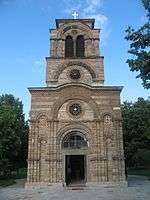
The Gomionica Monastery (Serbian Cyrillic: Манастир Гомионица) is a Serbian Orthodox monastery dedicated to the Presentation of Mary and located at the village of Kmećani, 42 kilometres west of Banja Luka, in the Republika Srpska entity of Bosnia and Herzegovina. The monastery is the spiritual centre of the region known as Zmijanje.[1]
It was founded before 1536, though the exact date of its foundation is unknown. It was referred to as Zalužje in 16th-century sources, while its current name comes from a nearby river. In the second half of the 16th century, the abbot of the monastery was credited by the Ottomans for the peaceful attitude of the population of a wide area around Gomionica.[1]
The monastery may have been abandoned, at least partially, at the end of the 17th century (after the Great Turkish War), and during the 1730s. The church was refurbished several times during the 18th and 19th centuries. Writer Petar Kočić attended the elementary school organised at the monastery. It was badly damaged during World War II, and its abbot, Serafim Štrkić, was murdered in 1941 by the Nazi-affiliated Croatian Ustaše.[2]
After the war, Gomionica became a female monastery. In 1953, it was designated as a cultural monument of Yugoslavia, and in 2006, it was proclaimed a National Monument of Bosnia and Herzegovina. The treasury of Gomionica contains icons created in the 16th to 19th centuries, as well as manuscripts and printed books created in the 14th to 17th centuries. A silver-gilt cross formerly owned by the monastery, made in 1640, is now in the collection of the University of London, which acquired it from the private collection of Thomas Gambier Parry.[2]
References
External links
|
|---|
|
|
|
|
|
|
|---|
| | | | Patriarchs (since 1346) |
|---|
| 1346–1463 | |
|---|
| 1557–1766 | |
|---|
| since 1920 | |
|---|
|
| | | Heads of the Serbian Orthodox Church in the Habsburg Monarchy (1690–1920) |
|---|
| | |
|---|
| | |
|---|
| Metropolitans of Belgrade and Karlovci 1726–1739 | |
|---|
| | |
|---|
| | |
|---|
|
| | | |
|---|
| 1831–1920 |
- Melentije Pavlović
- Petar Jovanović
- Mihailo Jovanović
- Teodosije Mraović
- Inokentije Pavlović
- Dimitrije Pavlović
|
|---|
|
| | |
|
|
|
|
|
|---|
| | Serbia |
- Church of Saint Sava
- St. Michael's Cathedral
- St. George, Banovo Brdo
- Ružica
- St. Mark's Church
- St. Basil of Ostrog
- St. Achillius, Arilje
- Peter's Church, Ras
- Cave Church, Lukovo
- Štava Church
- Odžaklija
- Kađenica
- Lazarica Church
- Church of St. George, Lukovo
- Church of Holy Ascension, Krupanj
- Saint George's Cathedral (Novi Sad)
- the Assumption, Zrenjanin
- Our Lady of Ljeviš*
- Church of the Virgin Hodegetria*
- Church of St. Elijah, Podujevo*
- Church of St. Nicholas, Prizren*
- Mala Gospojina Church*
- Christ the Saviour Cathedral, Pristina*
|
| |
|---|
| | Montenegro | |
|---|
| Bosnia and
Herzegovina | |
|---|
| | Croatia |
- Church of the Holy Venerable Mother Parascheva
- Church of the Transfiguration of the Lord, Trpinja
- Church of St. Nicholas, Vukovar
- Church of Pentecost, Vinkovci
- Church of St. George, Kneževo
- Church of the Assumption of the Blessed Virgin, Negoslavci
- Church of Pentecost, Markušica
- Church of St. George, Bobota
- Church of St. Stephen, Borovo
- Church of the Nativity of the Virgin, Srijemske Laze
- Church of St. Peter and Paul, Bolman
- Church of St. Stefan Štiljanović, Karanac
- Church of St. Nicholas, Mirkovci
- Church of the Nativity of the Virgin Mary, Gaboš
- Church of St. Nicholas, Jagodnjak
- Church of St. Demetrius, Dalj
- Serbian Orthodox Cathedral, Zagreb
- Church of St. George, Grubišno Polje
- Church of St. Nicholas, Karlovac
- Church of the Nativity of the Virgin, Drežnica
- Church of the Holy Apostles Peter and Paul, Štikada
- Church of St. George, Varaždin
- Church of the Holy Annunciation, Dubrovnik
- Orthodox Church in Knin
- Church of St. Peter and Paul, Tepljuh
- St. Spyridon Church, Peroj
- Church of St. Nicholas, Rijeka
- Church of St. Nicholas, Vrlika
- Orthodox church of Holy Salvation, Cetina
|
|
|---|
| | United Kingdom | |
|---|
| | United States | |
|---|
| Other
countries |
- St. Archangel Michael Serbian Orthodox Church (Toronto), Canada
- Sts. Cyril and Methodius Church, Slovenia
- Serbian Church in Arad, Romania
- St. Sava Church, Paris, France
- Saint Spyridon Church, Trieste, Italy
- Annunciation Church, Szentendre, Hungary
- Transfiguration Church, Szentendre, Hungary
- Saint Sava Serbian Orthodox Church, Stockholm, Sweden
|
|---|
| | Notes | * indicate churches in Kosovo, which is the subject of a territorial dispute between Serbia and Kosovo. |
|---|
|
|
|
Coordinates: 44°43′47″N 16°54′37″E / 44.729722°N 16.910278°E / 44.729722; 16.910278