Goose Lake (Oregon–California)
| Goose Lake | |
|---|---|
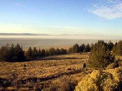 An alkaline dust storm blowing into Lakeview, Oregon, over the deeper north end of the lake (seen from U.S. Route 395 near Sugar Hill, 2009) | |
| Location |
Fremont National Forest and Modoc National Forest Lake County, Oregon and Modoc County, California |
| Coordinates | 41°55′0″N 120°26′4″W / 41.91667°N 120.43444°WCoordinates: 41°55′0″N 120°26′4″W / 41.91667°N 120.43444°W |
| Lake type | Pluvial and alkaline |
| Primary inflows |
Willow Creek Thomas Creek |
| Primary outflows | Closed basin with rare flows to the Pit River |
| Catchment area | 1,080 sq mi (2,800 km2)[1] |
| Basin countries | United States |
| Max. length | 42 km (26 mi) |
| Max. width | 15 km (9.3 mi) |
| Surface area | 147 sq mi (380 km2)[2] |
| Max. depth | 8 m (26 ft) |
| Shore length1 | 110 km (68 mi) |
| Surface elevation | 1,434 m (4,705 ft) |
| Settlements |
Fairport, California Willow Ranch, California |
| References | [1][2][3] |
| 1 Shore length is not a well-defined measure. | |
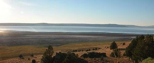
Goose Lake is a large alkaline lake in the Goose Lake Valley on the Oregon–California border in the United States. Like many other lakes in the Great Basin, it is a pluvial lake that formed from precipitation and melting glaciers during the Pleistocene epoch.[4][5] The north portion of the lake is in Lake County, Oregon, and the south portion is in Modoc County, California. The mountains at the north end of the lake are part of the Fremont National Forest, and the south end of the lake is adjacent to Modoc National Forest lands. Most of the valley property around the lake is privately owned agricultural land, though Goose Lake State Recreation Area is on the Oregon side of the lake.
Goose Lake is the center of a semi-closed drainage basin. Its watershed is normally endorheic, but sometimes flows into the Pit River, part of the Sacramento River watershed, during periods of high water following heavy rainfall or snowmelt. During the 1970s and 1980s, the USGS defined Goose Lake as part of the Sacramento's watershed,[1] but has redefined Goose Lake's watershed as a closed basin.[2]
Background
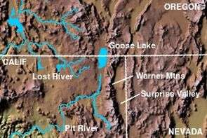
Goose Lake is part of a geological trough which runs from Oregon southward past Death Valley, the Walker Lane.
Goose Lake State Recreation Area includes a campground with various amenities. The park attracts wildlife watchers, campers, and boaters. The campground is open mid-April to mid-October.[6] It is habitat to many flora and fauna including western grebe, long-billed curlew, and a large herd of mule deer which spend much of the time in the 48-site campground.
Recreational activities on or around the lake include kayaking, canoeing, and hunting, but not fishing. When the lake is full, it has a maximum depth of 24 feet (7.3 m).
The lake is located near the historic Fandango Pass route that 19th century settlers used to enter California. In the mid-19th century, particularly during the California Gold Rush, the Applegate-Lassen Cut-Off of the California Trail left the main route of that Trail near present-day Rye Patch Reservoir, and crossed the Black Rock Desert, on the way to Goose Lake and the California gold fields. The Lassen Cut-Off continued down the Pit River into California's Central Valley, while the Applegate Cut-Off went into southern Oregon along the Lost River.
The lake completely dried up in the years 1851, 1852, 1926, 1929–1934, 1992,[7] 2009, 2013, 2014, and 2015. Goose Lake overflowed into the Pit River watershed in 1868.[8] Formerly, Goose Lake was the regular source of the Pit River, but water diversion has caused the lake level to drop below its outlet. The Pit River's source is now south of Goose Lake, and the lake's salinity is increasing, threatening fish populations. During rare high water levels, Goose Lake still spills into the Pit River.[5][9]
See also
| Wikimedia Commons has media related to Goose Lake. |
References
- 1 2 3 "Boundary Descriptions and Names of Regions, Subregions, Accounting Units and Cataloging Units". USGS. Retrieved November 16, 2010.
- 1 2 3 "Watershed Boundary Dataset". USDA, NRCS, National Cartography and Geospatial Center. Retrieved September 4, 2010. ArcExplorer GIS data viewer.
- ↑ U.S. Geological Survey Geographic Names Information System: Goose Lake
- ↑ Grayson, p. 87, 93–94, 96
- 1 2 Green, p. 75
- ↑ "Goose Lake State Recreation Area". Oregon Parks and Recreation Department. Retrieved November 8, 2014.
- ↑ "Goose Lake - Fish, Wildlife and Rare Plants". Pit River Watershed Alliance. October 10, 2007. Retrieved November 16, 2009.
- ↑ Grayson, p. 94
- ↑ "Welcome to the Pit River Watershed Alliance". Pit River Watershed Alliance. October 10, 2007. Retrieved November 16, 2009.
Works cited
- Grayson, Donald K. (2011). The Great Basin: A Natural Prehistory (Revised ed.). University of California Press. ISBN 978-0-520-26747-3.
- Green, Stewart M. (2005). Scenic Driving California (Second ed.). Guilford, Connecticut: The Globe Pequot Press. ISBN 0-7627-3481-7.