Grafengehaig
| Grafengehaig | ||
|---|---|---|
| ||
 Grafengehaig | ||
Location of Grafengehaig within Kulmbach district 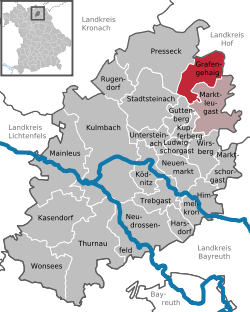 | ||
| Coordinates: 50°12′N 11°34′E / 50.200°N 11.567°ECoordinates: 50°12′N 11°34′E / 50.200°N 11.567°E | ||
| Country | Germany | |
| State | Bavaria | |
| Admin. region | Oberfranken | |
| District | Kulmbach | |
| Municipal assoc. | Marktleugast | |
| Government | ||
| • Mayor | Fritz Schramm | |
| Area | ||
| • Total | 20.80 km2 (8.03 sq mi) | |
| Population (2015-12-31)[1] | ||
| • Total | 887 | |
| • Density | 43/km2 (110/sq mi) | |
| Time zone | CET/CEST (UTC+1/+2) | |
| Postal codes | 95356 | |
| Dialling codes | 09255 | |
| Vehicle registration | KU | |

Grafengehaig is a municipality in the district of Kulmbach in Bavaria in Germany.
It is a part of the Franconian Forest nature park.
City arrangement
Grafengehaig is arranged in the following boroughs:
|
|
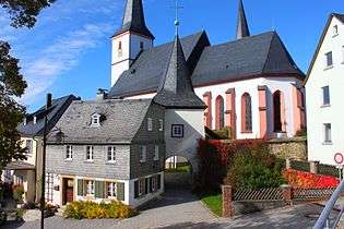
Fortified church of Grafengehaig
References
- ↑ "Fortschreibung des Bevölkerungsstandes". Bayerisches Landesamt für Statistik und Datenverarbeitung (in German). June 2016.
External links
![]() Media related to Grafengehaig at Wikimedia Commons
Media related to Grafengehaig at Wikimedia Commons
Towns and municipalities in Kulmbach | ||
|---|---|---|
This article is issued from Wikipedia - version of the 6/21/2015. The text is available under the Creative Commons Attribution/Share Alike but additional terms may apply for the media files.