Grand-Santi
| Grand-Santi | |
|---|---|
|
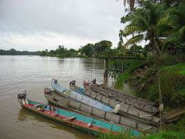
A view of Grand-Santi, towards the village | |
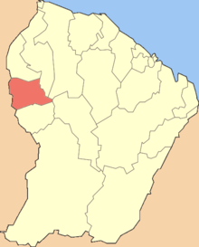 Location of the commune (in red) within French Guiana | |
| Coordinates: 4°16′26″N 54°22′58″W / 4.2739°N 54.3828°WCoordinates: 4°16′26″N 54°22′58″W / 4.2739°N 54.3828°W | |
| Country | France |
| Overseas region and department | French Guiana |
| Arrondissement | Saint-Laurent-du-Maroni |
| Intercommunality | Ouest Guyanais |
| Government | |
| • Mayor (2014-2020) | Paul Martin |
| Area1 | 2,112 km2 (815 sq mi) |
| Population (2012)2 | 6,029 |
| • Density | 2.9/km2 (7.4/sq mi) |
| INSEE/Postal code | 97357 / 97340 |
|
1 French Land Register data, which excludes lakes, ponds, glaciers > 1 km² (0.386 sq mi or 247 acres) and river estuaries. 2 Population without double counting: residents of multiple communes (e.g., students and military personnel) only counted once. | |
Grand-Santi is a commune of French Guiana, an overseas region and department of France located in South America.
History
The commune was originally called Grand-Santi-Papaichton and included the now independent communes of Apatou and Papaichton. On 12 November 1976 Apatou was detached from Grand-Santi-Papaichton and became an independent commune. On 1 January 1993 Papaichton was also detached from Grand-Saint-Papaichton and became an independent commune. On that occasion, the name of the commune was shortened into Grand-Santi.
Transportation
The Grand-Santi Airport is located 1 km (0.54 NM) northeast of Grand-Santi.[1]
See also
References
- ↑ SOGS – GRAND SANTI. AIP from French Service d'information aéronautique, effective 8 December 2016.
| Wikimedia Commons has media related to Grand-Santi. |
This article is issued from Wikipedia - version of the 2/5/2015. The text is available under the Creative Commons Attribution/Share Alike but additional terms may apply for the media files.