Grand Junction Isle
Grand Junction Isle is a small island in the River Thames on the reach above Molesey Lock at Sunbury-on-Thames, Surrey, England. It is just downstream of Sunbury Court Island, which is three times longer and also close to the north bank.
Geography
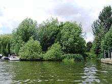
The island is more of a lozenge than ellipse and at its greatest extent 35m long and 15m wide within the low lying tree-covered somewhat tenuous land of the island are six weekend chalets of garden summerhouse size with mooring spaces and is connected to the northern bank in the residential far south-east of Sunbury by a footbridge.[1]
History
The island takes its name from the Grand Junction Waterworks Company which was one of three companies operating its 'Hampton Water Works' which straddle the Hampton/Sunbury border such that the border has been moved to accommodate the westernmost reservoir within Hampton. The company built a water intake on the island to feed that reservoir and others, which in turn feed into filter beds, filters and advanced chemical and electromagnetic treatment works owned and operated by Thames Water. The island was previously known as "Purvis Ait". [2]It is currently owned by The Environment Agency.
See also
References
- ↑ Grid square map Ordnance survey website
- ↑ Thacker, Fred S (1968) [First published 1920]. The Thames Highway: Volume II Locks and Weirs (New impression, 1st. ed.). Newton Abbot: David & Charles. ISBN 978-0-7153-4233-6. OCLC 55209571.
External links
| Next island upstream | River Thames | Next island downstream |
| Sunbury Court Island | Grand Junction Isle | Platts Eyot |
Coordinates: 51°24′35.5″N 00°23′18″W / 51.409861°N 0.38833°W