Grand Sable Lake
| Grand Sable Lake | |
|---|---|
 Grand Sable Lake | |
| Location | Alger County, Michigan |
| Coordinates | 46°18.14′N 85°29.76′W / 46.30233°N 85.49600°WCoordinates: 46°18.14′N 85°29.76′W / 46.30233°N 85.49600°W |
| Primary inflows | Towes, Rhody, DeMull Creeks. |
| Primary outflows | Sable Creek |
| Basin countries | United States |
| Max. length | 2.2 Mi. |
| Max. width | 0.7 Mi. |
| Surface area | 630 Acres |
| Average depth | 40 ft. |
| Max. depth | 85 ft. |
| Surface elevation | 741 feet (226 m)[1] |
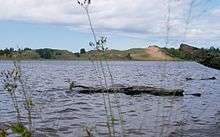
Grand Sable Lake is an undeveloped lake in Michigan's Upper Peninsula near the town of Grand Marais, Michigan. It lies within the boundaries of the Pictured Rocks National Lakeshore.
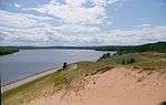
County Highway H-58 runs along the northwestern shore of the lake and provides access to the Grand Sable Dunes which overlook the lake. Additionally, there is a sandy beach and picnic area available to visitors. There is a concrete boat access site on the eastern shore of the lake.
The soils around Grand Sable Lake are very sandy and the shoreline is mostly wooded [2]
See also
References
| Wikimedia Commons has media related to Grand Sable Lake. |
View of Grand Sable Dunes across Grand Sable Lake from the boat access area
This article is issued from Wikipedia - version of the 10/3/2016. The text is available under the Creative Commons Attribution/Share Alike but additional terms may apply for the media files.