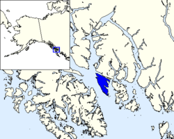
Gravina Island

Gravina Island is an island in the Gravina Islands of the Alexander Archipelago in southeastern Alaska. It is 21 miles (34 km) long and about 9.5 miles (15.3 km) wide,[1] with a land area of 94.81 square miles (245.6 km2). The island had a population of 50 people at the 2000 census.
The Spanish explorer Jacinto Caamaño named the Gravina Islands group in 1792. George Vancouver applied the name to Gravina Island itself in 1793. The name honors Federico Carlos Gravina y Nápoli.[2]
Ketchikan International Airport is located on Gravina Island across the Tongass Narrows (½ mile) from Ketchikan and is reached by a ferry service which takes between three and seven minutes and runs at least every half-hour.
Flora and fauna
A variety of wildlife and vegetation are found on Gravina Island including a disjunctive population of the Crater Lake Newt, a subspecies of the Rough-skinned Newt, whose northern range is in Alaska.[3]
Proposed bridge
In August 2005 the 2005 Highway Bill provided for $223m to build the Gravina Island Bridge between Gravina Island and nearby Ketchikan, on Revillagigedo Island. The provisions were negotiated by Alaska's Rep. Don Young. This bridge had been nicknamed "The Bridge to Nowhere" by its critics, though its purpose was intended to replace the auto ferry which is currently the only connection between Ketchikan and its airport. While the federal earmark was withdrawn, the state of Alaska is continuing to study improvements in access to the airport, which may include improvements to the ferry service.[4]
References
| Wikimedia Commons has media related to Gravina Island, Alaska. |
- ↑ U.S. Geological Survey Geographic Names Information System: Gravina Island
- ↑ Wagner, Henry (1937). The Cartography of the Northwest Coast of America to the Year 1800. Berkeley: University of California Press. p. 390.
- ↑ C. Michael Hogan (2008) Rough-skinned Newt (Taricha granulosa), Globaltwitcher, ed. N. Stromberg
- ↑ State studying ways to link Ketchikan, Gravina Island. Bohrer, Becky. Juneau Empire, 1 July 2013
Coordinates: 55°18′14″N 131°47′11″W / 55.30389°N 131.78639°W