Grey Butte Field Airport
| Grey Butte Field Airport Grey Butte Auxiliary Airfield | |||||||||||
|---|---|---|---|---|---|---|---|---|---|---|---|
|
2006 USGS airphoto | |||||||||||
| IATA: none – ICAO: none – FAA LID: 04CA | |||||||||||
| Summary | |||||||||||
| Serves | Palmdale, California | ||||||||||
| Coordinates | 34°33′59″N 117°40′13″W / 34.56639°N 117.67028°W | ||||||||||
| Map | |||||||||||
 04CA Location of Grey Butte Field Airport | |||||||||||
| Runways | |||||||||||
| |||||||||||
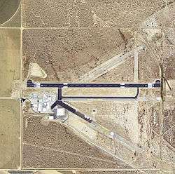
Grey Butte Field Airport is a private airport located 25 miles east of Palmdale, California. It is owned by General Atomics of San Diego. Its primary use is the development and testing of Unmanned Aerial Vehicles (UAV) for the United States military.
History
During World War II, the airport was designated as Grey Butte Auxiliary Airfield (No 4), and was an auxiliary training airfield for Victorville Army Airfield, California.
The wartime runways are abandoned and now used by General Atomics for their UAV testing.
The airfield was assigned the FAA location identifier GVM, but on July 26, 2012, the airport's location identifier was changed to 04CA..[1]
See also
References
![]() This article incorporates public domain material from the Air Force Historical Research Agency website http://www.afhra.af.mil/.
This article incorporates public domain material from the Air Force Historical Research Agency website http://www.afhra.af.mil/.
- ↑ "Location Identifiers". Federal Aviation Administration. Retrieved 2012-12-19.
- Abandoned & Little-Known Airfields: California - Southern Palmdale area
External links
| Flying Training |
|  | ||||||
|---|---|---|---|---|---|---|---|---|
| Technical Training |
| |||||||