Grayrigg railway station
| Grayrigg railway station | |
|---|---|
| Location | |
| Place | Grayrigg |
| Area | South Lakeland |
| Coordinates | 54°21′31″N 2°37′09″W / 54.3585°N 2.6191°WCoordinates: 54°21′31″N 2°37′09″W / 54.3585°N 2.6191°W |
| Grid reference | SD598960 |
| Operations | |
| Pre-grouping | London and North Western Railway |
| Post-grouping | London, Midland and Scottish Railway |
| Platforms | 2 |
| History | |
| 1849 | first station opened |
| November 1861 | resited |
| 1 February 1954 | Closed to passengers |
| Disused railway stations in the United Kingdom | |
|
Closed railway stations in Britain A B C D–F G H–J K–L M–O P–R S T–V W–Z | |
|
| |
Grayrigg railway station in Lambrigg parish, was situated on the course of the original Lancaster and Carlisle Railway (L&CR) (the West Coast Main Line) between Lancaster and Penrith. It served the village and rural district of Grayrigg, Cumbria, England. The new station opened in November 1861, and closed on 1 February 1954[1] replacing the L&CR station that was located 3.22km west of the station and closed in 1849.[1]
| Lancaster & Carlisle Railway |
|---|
Legend |
The station
The station had two platforms, a signal box to the north and a station master's house. The goods yard had a weighing machine and a coal yard.[2] The much modified station house survives, the platforms have however been demolished and the line has been electrified. An electricity supply sub-station is located here and the railway becomes triple track here for a distance running north.
The old Ingleton Branch Line's Low Gill Viaduct lay nearby. This line was completed in 1861 and served the towns of Ingleton, Kirkby Lonsdale and Sedbergh. It closed to passengers in 1954 and was dismantled in 1967.[3]
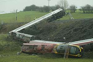
The Grayrigg derailment
A fatal railway accident occurred on 23 February 2007, just to the south of Grayrigg. The derailment to a London (Euston) to Glasgow Virgin Pendolino express was caused by a faulty set of points controlled from the nearby Lambrigg ground frame. The points which caused the derailment, and points on the opposite line, were removed from the track following the derailment. The track is now welded continuously for 2.2 miles here, including the section over the Docker Viaduct. The overhead electrical line equipment had to be replaced, double-line catenary from a single stand being used.
Stations on the line
The next station on the line towards Carlisle was Low Gill and the preceding station was Oxenholme.
References
- Notes
- Sources
- Butt, R.V.J. (1995). The Directory Of Railway Stations. Patrick Stephens Limited. ISBN 978-1-85260-508-7.