Grays Peak (British Columbia)
This article is about the mountain in British Columbia. For other mountains with similar names, see Gray Peak.
| Grays Peak | |
|---|---|
 Grays Peak | |
| Highest point | |
| Elevation | 2,753 m (9,032 ft) [1] |
| Prominence | 223 m (732 ft) [1] |
| Coordinates | 49°43′36″N 117°07′28″W / 49.72667°N 117.12444°WCoordinates: 49°43′36″N 117°07′28″W / 49.72667°N 117.12444°W [2] |
| Geography | |
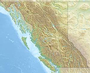
| Location | British Columbia, Canada |
| Parent range | Kokanee Range |
| Topo map | NTS 082F11 |
Grays Peak is a mountain in southeast British Columbia, Canada.[3] It is located in Kokanee Glacier Provincial Park in the Kootenays,[2] and is best known for being the mountain pictured on the label of Kokanee beer.[1]
Location
Grays Peak is located at the south end of Kokanee Glacier Provincial Park, between the headwaters of Kokanee Creek and Coffee Creek.[3]
Name
Grays Peak was named after brothers John Balfour Gray and Robert Hampton Gray (VC), who were born in Trail, BC, and grew up in Nelson, BC. Both brothers were killed in WWII. The name was adopted by the Geographic Board of Canada on 12 March 1946.[3]
External links
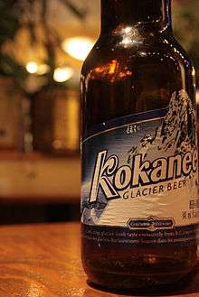
Grays Peak is featured on the label of Kokanee beer.
- BC Parks, Map of Kokanee Glacier Provincial Park(PDF), (shows mountains, including Grays Peak)
References
- 1 2 3 "Grays Peak". Bivouac.com. Retrieved 2010-07-24.
- 1 2 Natural Resources Canada, Geographical Names of Canada database, Grays Peak. Accessed 2010-07-24
- 1 2 3 "Grays Peak". BC Geographical Names. Retrieved 2010-07-24.
This article is issued from Wikipedia - version of the 12/6/2015. The text is available under the Creative Commons Attribution/Share Alike but additional terms may apply for the media files.