Green Lane, Coventry
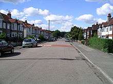
Green Lane is a mainly residential district in Coventry, England.[1] The term Green Lane is sometimes also used in a generic sense to refer to road of Green Lane itself and its immediate environs. It is generally considered as one of the more prosperous areas of the city.
The suburb of Finham lies to its south, Styvechale/Stivichall is to the east, the War Memorial Park to its north and the suburbs of Cannon Park and Canley to its west. The city centre is approximately 1.75 miles (3 km) to the north. The main roads within the Green Lane suburb are Kenpas Highway (west), Green Lane (north), Woodside Avenue, Wainbody Avenue, Moat Avenue, Beanfield Avenue, Grasmere Avenue, Leasowes Avenue, Gretna Road, Gratton Court, Gregory Avenue, Sylvan Drive, Regency Drive, Oak Tree Avenue and Medland Avenue.
The A45 dual-carriageway from Coventry to Birmingham bisects the suburb north-south. A row of shops and a large pub line part of this section of road. Green Lane itself continues south through Finham and onto the B4113 road connecting Coventry with the village of Stoneleigh, Warwickshire.[1]
History
The Green Lane (the road) is one of the longest in the area, and it is divided into a shorter northern part (in Green Lane) and a longer southern part (in Finham).[1] The two portions of Green Lane (the road) originally formed a crossroads with the A45, but after the A45 was converted into a dual carriageway in the 1950s (approx date) the two parts of Green Lane became discontinuous; however, a subway was built under the A45 for pedestrians in the early-1970s.
Green Lane Ex-Services Club
The club was set up over 50 years ago by Ex-Service men after the Second World War. The land was given to the club by Bassett Green, the man who donated the statue of Lady Godiva to the City of Coventry.
Inside the walls of the club, under the apex roof, is the original structure consisting of two arch shaped Nissen huts. During the war these Nissen Huts stood half a mile away from the current location on the intersection of Kenpas Highway (A45) and Leamington Road (B4113) and was used as a garage for tank repairs. After the war they were bought for £500 and moved to the current location at the bottom of Beanfield Avenue on Leasowes Avenue.
To build the brick exterior wall and existing roof funds were raised by selling some land between the club house and Moat Avenue.
The club has a full trophy cabinet showing the successes at football, snooker, darts and other sporting events over many years.
Education
References
External links
Coordinates: 52°22′59″N 1°31′30″W / 52.383°N 1.525°W