Green Line (TRAX)
| Green Line | |||||||||||||||||||||||
|---|---|---|---|---|---|---|---|---|---|---|---|---|---|---|---|---|---|---|---|---|---|---|---|
|
| |||||||||||||||||||||||
|
Green Line at Gallivan Plaza | |||||||||||||||||||||||
| Overview | |||||||||||||||||||||||
| Type | Light rail | ||||||||||||||||||||||
| System | UTA TRAX | ||||||||||||||||||||||
| Status | Operating | ||||||||||||||||||||||
| Locale |
Salt Lake Valley, Utah | ||||||||||||||||||||||
| Termini |
Airport Station West Valley Central Station | ||||||||||||||||||||||
| Stations | 18 | ||||||||||||||||||||||
| Operation | |||||||||||||||||||||||
| Opened |
August 7, 2011 (original) April 14, 2013 (Airport extension) | ||||||||||||||||||||||
| Owner | Utah Transit Authority (UTA) | ||||||||||||||||||||||
| Operator(s) | UTA | ||||||||||||||||||||||
| Rolling stock | Typical: Siemens S70 vehicles[1] | ||||||||||||||||||||||
| Technical | |||||||||||||||||||||||
| Number of tracks | 2 | ||||||||||||||||||||||
| Track gauge | 1,435 mm (4 ft 8 1⁄2 in) standard gauge | ||||||||||||||||||||||
| Electrification | Overhead catenary | ||||||||||||||||||||||
| Operating speed | Maximum: 55 mph (89 km/h)[2] | ||||||||||||||||||||||
| Route number | 704 | ||||||||||||||||||||||
| |||||||||||||||||||||||

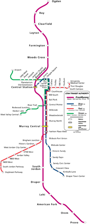
The Green Line is a light rail line on the Utah Transit Authority's (UTA) TRAX system in Salt Lake City, Utah, in the United States, operated by the Utah Transit Authority (UTA). It opened on August 7, 2011, and runs between Airport Station at the Salt Lake City International Airport and West Valley Central Station in West Valley City (via Downtown Salt Lake City) serving a total of eighteen stations: thirteen in Salt Lake City, one in South Salt Lake, and four in West Valley City.
Route
The TRAX Green Line is designated as UTA Route 704.
West Valley Central to Downtown
The Green Line begins with the West Valley Central Station at the West Valley Intermodal Center, which is located at 2750 West 3590 South in West Valley City. Just after leaving that station it immediately passes between the West Valley City Police Department and the West Valley City Hall, before heading north down the middle of Constitution Boulevard (South 2700 West). After passing by the northern end of Valley Fair Mall, it crosses West 3500 South (SR-171) and continues north in the median of Constitution Boulevard to West 3100 South. It then heads east along the south side of West 3100 South (with a sidewalk between the tracks and the roadway) and crosses over I-215 and past the north side of the Maverik Center. Just after the Maverik Center it turns north, resuming a course in the median of the street, and immediately reaches the next station, Decker Lake, at 3070 South 2200 West. After Decker Lake it heads northeast in the median of Decker Lake Drive until that street heads due north at Research Way (West 2770 South). At Research Way the Green Line turns east again and heads down the median of that street. Just before South Redwood Road (South 1700 West/SR-68) is Redwood Junction.
Leaving the roadway right-of-way, after an at-grade crossing on South Redwood Road, the Green Line continues east, crossing Lester Street (South 1595 West), until it reaches the Jordan River. The tracks head north until they cross West Parkway Avenue (West 2455 South) and then runs down the middle of Winston Street (South 1070 West) to River Trail at 2340 South. After that station it continues north for about a half a block before leaving the street via an at-grade crossing and heading east. It immediately crosses the Jordan River (passing from West Valley City into South Salt Lake), and then follows along the south side of the 21st South Freeway (SR-201). After passing the Jordan River Service Center (one of UTA's two TRAX maintenance facilities) on the south, the track use a series of viaducts to cross South 900 West, South 700 West, the north end of Union Pacific's Roper Rail Yard, the UTA FrontRunner tracks, and South 600 West before reaching the "Spaghetti Bowl" (the junction of I-15, I-80 and SR-201).
From South 600 West the Green Line briefly follows the route of the old Denver and Rio Grande Western Railroad (D&RGW) Sugar House Branch, which goes under I-15/I-80 and then briefly runs along the south side of West Andy Avenue to South 300 West. After crossing South 300 West it continues east until about 220 West where it reaches the Union Pacific right-of-way and takes a sharp turn north as it merges with the Blue and Red lines), before entering Central Pointe, which is just south of West 2100 South (SR-201).Central Pointe is the only TRAX station served by the S Line.[3] The S Line platform is situated just southeast of the TRAX platform. (The S Line provides streetcar service east to the Fairmont stop in the Sugar House neighborhood of Salt Lake City.)
Upon crossing West 2100 South the three TRAX lines leave South Salt Lake and enter Salt Lake City and continue north as they cross West 1700 South and West 1300 South. Just north of West 1300 South is Ballpark, which provides service to Smith's Ballpark. (Immediately north of this station is a non-revenue track that extends northwest to South 400 West at West 900 South and then north to West 600 South.) After Ballpark the three lines continue north in the center median of South 200 West, crossing under the 900 South/I-15 on and off ramps, until they reach the next station, 900 South. This station, which is just north of West 900 South, is an infill station[4] and the last stop before the TRAX lines reach Downtown Salt Lake City.
The three lines continue north in the median of South 200 West, crossing West 800 South, until they reach West 700 South. At West 700 South they turn east and proceed down the middle of that street for two blocks, crossing South West Temple Street (SR-270). At South Main Street, the lines turn north and continue down the center median of that street and cross West 600 South (Martin Luther King Jr Boulevard/SR-269 eastbound), pass between the Grand America Hotel and the Little America Hotel, and then cross West 500 South (Cesar E Chavez Boulevard/SR-269 westbound). Just north of West 500 South and slightly west of the Scott Matheson Courthouse, is the first station within the Free Fare Zone, Courthouse. At West 400 South (University Boulevard/US Highway 89) the Red Line turns east and heads toward Library and eventually the University of Utah while the Green and Blue lines continue north. After crossing West 300 South (West Broadway) the two lines reach Gallivan Plaza, which is just west of the Wells Fargo Center and the Gallivan Center.
Continuing in the median of South Main Street, the Green and Blue lines continue north crossing West 200 South and West 100 South before reaching City Center. This station is in the middle of the new City Creek Center commercial and residential development. At the north end of South Main Street the two lines turn west down the middle of West South Temple Street for a little more than a block before reaching the next station, Temple Square. This station is just southwest of Temple Square (home to the Salt Lake Temple, Salt Lake Tabernacle, and other notable buildings of The Church of Jesus Christ of Latter-day Saints). It is also just south of the Family History Library, about two blocks south of the LDS Conference Center, and immediately north of Abravanel Hall and the Salt Palace.
Continuing down the median of West South Temple Street the lines reach Arena (formerly Delta Center). This station is immediately north of the EnergySolutions Arena, east of the Union Pacific Depot, and south of LDS Business College. Arena was formerly the terminus of both the Sandy/Salt Lake and the old University Line. However, an extension opened on April 16, 2008 which provided access to the Salt Lake City Intermodal Hub and the new FrontRunner commuter rail train. Eventually, the Sandy/Salt Lake Line was renamed the Blue Line and the University Line was shut down. About this same time the Green Line was created and its route continued, along with the Blue Line, on to Salt Lake Central (Salt Lake City Intermodal Hub). However, with the rerouting of the Green Line to accommodate the Airport Extension, Arena became the temporary terminus of the Green Line from December 9, 2012 to April 13, 2013. Arena is the last station on the Green Line within the Free Fare Zone.
Downtown to Airport
Following Arena, the two lines continue on to 400 West where they divide paths. The Blue Line turns south down the middle of South 400 West towards Planetarium and eventually ending at the Salt Lake Intermodal Hub, while the Green Line turns north. After about a block down the middle of North 400 West, the Green Line turns west to run on the north side of West North Temple Street (West 100 North) and ascends the North Temple Viaduct to the TRAX platform of the next station, North Temple Bridge/Guadalupe. This station is often referred to as simply North Temple and is the only bi-level station operated by UTA. It is also flying junction since Green Line tracks cross over the FrontRunner and Union Pacific tracks. The TRAX platform is on the viaduct and the FrontRunner platform is at ground level (at grade) just north of the viaduct, with escalators and stairs to transfer passengers between. This station is also an infill station on the FrontRunner line and was built for the express purpose of creating a common station between the Green Line and the FrontRunner.
Leaving North Temple Bridge/Guadalupe the Green Line crosses back over the Union Pacific right-of-way and descends to North 600 West. Just after crossing North 600 West the tracks jog from the north side of North Temple Street to the median and then cross back under I-15. Just after crossing North 800 West it reaches Jackson/Euclid. Continuing west down the median of West North Temple Street, it crosses North 900 West and North 1000 West before reaching Fairpark at 1150 West. This station is located immediately south of the Utah State Fairpark (home of the annual Utah State Fair and other events). Just after Fairpark, the Green Line crosses back over the Jordan River and passes the Rocky Mountain Power facility on the south before reaching Power at 1500 West.
From Power, the Green Line continues west down the median of West North Temple Street, crossing North Redwood Road, until it reaches the next to the last station on the line, 1940 W North Temple. From this station it crosses under I-215 and then continues down the median of Old Highway 186 as that road splits from West North Temple Street and heads southwest towards I-80. Just after crossing South 2400 West, the Green Line crosses to the north side of the road as Old Highway 186 continues southwest to I-80. The tracks continue on the north side of the I-80 right-of-way, crossing over the Surplus Canal, until Old Highway 186 curves north again just east of the I-80/Bangerter Highway (SR-154) interchange and then merges with Terminal Drive as that road heads northeast and then north to the Salt Lake City International Airport. The tracks parallel the east side of Terminal Drive until it reaches the Airport Station, which is located immediately south of Terminal One. There is direct access to the terminal from the north end of the platform.
Park and Ride
Many TRAX stations include free Park and Ride lots, with some lots having as few as six parking spaces and others having nearly 1200.[5] However, there are certain restrictions for all lots (for example, no 24-hour parking).[Note 1]
Free Fare Zone
UTA currently has a Free Fare Zone in Downtown Salt Lake City for transportation patrons that both enter and exit bus or TRAX service within the Zone. The Zone covers an area of approximately thirty-six city blocks and the boundaries are roughly North Temple, 200 East, 500 South, and 400 West. TRAX stations within the Zone include Arena, City Center, Courthouse, Gallivan Plaza (mistakenly identified as "Gallivan Center Station" on the Free Fare Zone map), Planetarium, and Temple Square. In addition, the Free Fare Zone also includes the area of the State Capitol (north to 500 North), the bus stops on 400 South between 200 East and 300 East, and three additional TRAX stations: Library, Old GreekTown, and Salt Lake Central.[7] In June 2012 UTA revealed plans to eliminate the Free Fare Zone, but by September 2012 it announced that it would continue the Zone, but with some minor adjustments, including when and how fares are collected.[8]
Airport extension
Construction began on October 22, 2008 on an extension to the Salt Lake City International Airport. The extension included six new TRAX stations. In addition to the Airport Station, five new stations were constructed along West North Temple Street (West 100 North), including one on top of the newly built North Temple Viaduct bridge. The old bridge was torn down and a new one constructed as part of the project.[9] The new bridge features a TRAX station on top and a FrontRunner commuter rail station underneath. After December 9, 2012, service on the Green Line was cut back to Arena in order to prepare for test trains and service to the Airport, thus permanenty ending service (via the Green Line) to the first three stations of the former route (Salt Lake Central, Old GreekTown, and Planetarium). Service to the airport began April 14, 2013.[10]
Train schedule[Note 2]
On weekdays the first northbound Green Line trains (to the Airport Station) leave the Central Pointe and the West Valley Central Station at about 5:00 am and the first southbound train (to the West Valley Central Station) leaves the Airport Station at about 5:45 am. The last northbound train leaving the West Valley Central at 10:27 pm and the last southbound train leaving the Airport Station at 11:27 pm. However, the last southbound train only goes as far as the Central Pointe Station; the last southbound train to the West Valley Station leaves the Airport Station at 10:42 pm.
On Saturdays the first northbound trains leave the Central Pointe Station at about 5:00 am and the West Valley Central Station at about 6:15 am; the first southbound train leaves the Airport Station at about 6:30 am; and the last northbound train leaves the West Valley Station at 10:19 pm and the last southbound train leaves the Airport Station at 11:16 pm.
On Sundays the first northbound trains leave the Central Pointe Station at about 9:00 am and the West Valley Central Station at about 10:00 am; the first southbound train leaves the Airport Station at about 9:30 am; and the last northbound train leaves the West Valley Central Station at 6:59 pm and the last southbound train leaves the Airport Station at 7:56 pm.
Green Line trains run every fifteen minutes on weekdays and every twenty minutes on weekends.[11]
Stations
All of UTA's TRAX and FrontRunner trains and stations, streetcars and streetcar stops, and all fixed route buses, are compliant with Americans with Disabilities Act and are therefore accessible to those with disabilities.[12] Signage at the stations, on the passenger platforms, and on the trains clearly indicate accessibility options. Ramps on the passenger platform and assistance from the train operator may be necessary for wheelchair boarding on Blue Line (weekdays only). These ramps are not used on weekends or on the Red or Green lines. In accordance with the Utah Clean Air Act and UTA ordinance, "smoking is prohibited on UTA vehicles as well as UTA bus stops, TRAX stations, and FrontRunner stations".[13]
| TRAX Green Line (Airport–Downtown Salt Lake–West Valley) | ||||||
| Station Name | Municipality | Opening Year |
UTA Rail Connections |
Park and Ride Lot |
Free Fare Zone |
Notes & Other Connections |
|---|---|---|---|---|---|---|
| Northwestern end of the line | ||||||
| Airport |
Salt Lake City | 2013 | No | No | Serving Salt Lake City International Airport | |
| 1940 West North Temple | ||||||
| Power |
||||||
| Fairpark |
Coming | Serving the Utah State Fairgrounds. | ||||
| Jackson/Euclid |
No | Serving Jackson and Euclid Elementary Schools | ||||
| North Temple Bridge/Guadalupe |
750 FrontRunner | Soon [Note 3] |
Serving the Guadalupe neighborhood, and West High School. | |||
| Arena |
1999 | 701 TRAX Blue Line | No | Yes | Serving EnergySolutions Arena | |
| Temple Square |
701 TRAX Blue Line | Serving the Salt Palace, Abravanel Hall, and Temple Square | ||||
| City Center |
701 TRAX Blue Line | Serving City Creek Center | ||||
| Gallivan Plaza |
701 TRAX Blue Line | Serving the Gallivan Plaza | ||||
| Courthouse |
701 TRAX Blue Line 703 TRAX Red Line |
Serving the Federal Courthouse and Third District Courthouse | ||||
| 900 South |
2005 | 701 TRAX Blue Line 703 TRAX Red Line |
No | |||
| Ballpark |
1999 | 701 TRAX Blue Line 703 TRAX Red Line |
Yes | Serving Smith's Ballpark | ||
| Central Pointe |
South Salt Lake | 701 TRAX Blue Line 703 TRAX Red Line 720 Streetcar S Line |
||||
| River Trail |
West Valley City | 2011 | No | Near the Jordan River, in the Chesterfield industrial area.[14] | ||
| Redwood Junction |
Serving the Decker Lake Business Park.[14] | |||||
| Decker Lake |
Yes | Serving the Maverik Center | ||||
| West Valley Central |
Serving Valley Fair Mall and West Valley City offices[15] Transfer to 35M 3500 South MAX bus rapid transit line | |||||
| Southwestern end of the line | ||||||
See also
- List of rapid transit systems
- Transportation in Salt Lake City
- TRAX (light rail)
- TRAX Blue Line
- TRAX Red Line
- FrontRunner
- UTA MAX
- S Line (formerly known as Sugar House Streetcar)
Notes
- ↑ Recently UTA announced that beginning July 1, 2013 it will start a one year pilot program involving most of its TRAX and FrontRunner Park and Ride lots. The purpose of the new program is to make rider connections with the Salt Lake City International Airport more convenient by avoiding the need to park at the airport. The program allows UTA patrons to park for an "unlimited amount of time" in the designated Park and Ride lots. In addition, UTA will allow free parking in all of its parking garages. Previous UTA policy limited parking to no more than 24 hours, except at its parking garages. As part of the year-long pilot program, "UTA will measure parking lot usage and monitor costs, maintenance requirements, impacts to snow removal and security issues before determining if the program will be extended." There are eight Park and Ride lots that are excluded from this test program and the 24-hour time limit will still apply to these lots. The only stations on the Green Line included in this program are West Valley Central and Ballpark.[6] Notwithstanding permission to park for extended periods in the applicable Park and Ride Lots, updated signage at the stations advises that the UTA Transit Police request that they be notified anytime a car is parked in one of the lots for more than seven days.
- ↑ Train schedule is current as of Change Day, 8 December 2013
- ↑ A Park and Ride Lot has been constructed at North Temple Bridge/Guadalupe Bridge Station. However, as of December 2013, it is still not open for use, nor has UTA provided an indication as to when the lot will be opened, other than "coming soon".
References
- ↑ "Siemens announces biggest US light rail order". railwaygazette.com. 16 May 2008. Retrieved 2 Apr 2014.
- ↑ Speckman, Stephen (5 Oct 2003). "Making TRAX on Sandy line: A speedy trip, but be sure to follow the rules". Deseret News. Salt Lake City: Deseret Digital Media. Retrieved 25 Jul 2009.
- ↑ Vo-Duc, Viviane (5 Sep 2013). "New streetcar S-line set to open Dec. 8 in Sugar House". Deseret News. Salt Lake City: Deseret Digital Media. Retrieved 17 Sep 2013.
- ↑ Daley, John (14 Apr 2004). "Two New Stops Planned for TRAX". ksl.com. Salt Lake City: Deseret Digital Media. Retrieved 25 Jul 2009.
- ↑ "TRAX Parking and Stops". rideuta.com. Utah Transit Authority. Retrieved 14 Dec 2012.
- ↑ "UTA Offers Free Multi-Day Parking". rideuta.com. Utah Transit Authority. 26 Jun 2013. Retrieved 19 Jul 2013.
- ↑ Free Fare Zone (JPG) (Map). Utah Transit Authority. Apr 2012. Retrieved 14 Dec 2012.
- ↑ "UTA Announces Changes to Free Fare Zone for Bus". rideuta.com. Utah Transit Authority. 26 Sep 2012. Retrieved 2 Apr 2012.
- ↑ Daley, John (16 Mar 2009). "Airport TRAX line to revamp North Temple". ksl.com. Salt Lake City: Deseret Digital Media. Retrieved 14 Aug 2011.
- ↑ "Airport TRAX Line to Open April 14". rideuta.com. Utah Transit Authority. 24 Oct 2012. Retrieved 2 Apr 2014.
- ↑ "TRAX" (PDF). rideuta.com. Utah Transit Authority. 8 Dec 2013. Retrieved 15 Dec 2013.
- ↑ "Fixed Route Accessibility". ridetuta.com. Utah Transit Authority. Retrieved 13 Mar 2013.
- ↑ "Rider Rules". rideuta.com. Utah Transit Authority. Retrieved 12 Mar 2013.
- 1 2 "WVC gets new intermodal hub". ksl.com. Salt Lake City: Deseret Digital Media. 17 Sep 2009. Retrieved 5 Apr 2013.
- ↑ West Valley TRAX Line Maps (Map). Utah Transit Authority. 2011. Archived from the original on May 23, 2011. Retrieved 16 Jun 2011.