Großer Adelberg
| Großer Adelberg | |
|---|---|
|
The Kleiner and Großer Adelberg | |
| Highest point | |
| Elevation | 567.4 m above sea level (NHN) (1,862 ft) [1] |
| Coordinates | 49°12′57″N 7°57′28″E / 49.215824°N 7.957734°ECoordinates: 49°12′57″N 7°57′28″E / 49.215824°N 7.957734°E |
| Geography | |
 Großer Adelberg near Annweiler am Trifels; Südwestpfalz, Rhineland-Palatinate (Germany) | |
| Parent range | Central Palatine Forest (Palatine Forest) |
| Geology | |
| Mountain type |
Bunter sandstone Rückenberg |
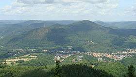
The Großer Adelberg is a hill, 567 metres high, in the Central Palatinate Forest in Germany.
Location
The hill is located on the territory of the town of Annweiler am Trifels north of the main urban area. To the northeast is the village of Gräfenhausen. To the east is the Krappenfels rock formation and the Mittelberg hill. To the south-southwest lies the Kleine Adelberg.
Access
To the south it is bounded by the B 10 and Landau–Rohrbach railway on which is Annweiler am Trifels station. Nearby are the Annweiler Youth Gymnastics Centre (Turnerjugendheim Annweiler) and a pumping station.
External links
| Wikimedia Commons has media related to Großer Adelberg. |
References
- ↑ LANIS. "Großer Adelberg on the topographic map by the Map Service of the Landscape Information Systems of the Rhineland-Palatinate Conservation Authority". Retrieved 2014-11-18.
This article is issued from Wikipedia - version of the 8/3/2016. The text is available under the Creative Commons Attribution/Share Alike but additional terms may apply for the media files.