Grosvenor Road railway station
| Grosvenor Road | |
|---|---|
 | |
| Location | Pimlico |
| Local authority | City of Westminster |
| Owner |
London, Chatham and Dover Railway/ London, Brighton and South Coast Railway |
| Number of platforms | 4 ? |
| Key dates | |
| 1867 | Opened (LC&DR) |
| 1870 | Opened (LB&SCR) |
| 1907 | Closed (LB&SCR) |
| 1911 | Closed (LC&DR) |
| Replaced by | none |
| Other information | |
| Lists of stations | |
|
| |
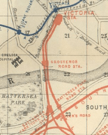
Grosvenor Road station was a London railway station located at the north end of Grosvenor Bridge on the approach tracks to Victoria station.
Victoria station was originally operated as two separate parts served by the London, Chatham and Dover Railway (LC&DR) and the London, Brighton and South Coast Railway (LB&SCR) and Grosvenor Road station was also operated in this way. The LC&DR station operated between 1867 and 1911 and the LB&SCR station operated between 1870 and 1907.
The station building of the LC&DR station remains on the eastern side of the tracks adjacent to Grosvenor Road (A3212) although no platforms remain at the elevated track level.
Pimlico


Pimlico terminus was built beside the new Chelsea Bridge, opposite the new Battersea Gardens. It was at the end of a 3 mi 20 ch (5.2 km) extension of the West End of London and Crystal Palace Railway from Wandsworth Common.
Its 22 acres (8.9 ha) site formally opened on Saturday 27 March 1858 and passengers used it from 29 March. Herapath's Journal said it, "was much admired for its spaciousness, convenient design, and economical construction".
There were 9 trains a day to Brighton and 25 to London Bridge. Pimlico closed on the eve of the opening of Victoria on 1 October 1860. Apart from Maiden Lane, it was the shortest lived London terminal.[1]
| Preceding station | Disused railways | Following station | ||
|---|---|---|---|---|
| London Victoria | London, Brighton and South Coast Railway Main Line |
Battersea Park | ||
| London, Chatham and Dover Railway Main Line |
Battersea Park Road | |||
References
- ↑ Railway Magazine March 1958 pp162-164 Charles E. Lee: The First West End Terminus
External links
Coordinates: 51°29′10″N 0°08′49″W / 51.48611°N 0.14694°W
