Guadarrama (river)
| Guadarrama | |
|---|---|
 Río Guadarrama. Community of Madrid, Spain | |
 Path of the Guadarrama | |
| Country | Spain |
| Basin | |
| Main source |
Siete Peak (Sierra de Guadarrama) 1,900 m (6,200 ft) |
| River mouth |
Tagus 500 m (1,600 ft) |
| Basin size | 1,708 km2 (659 sq mi) |
| Physical characteristics | |
| Length | 131.80 km (81.90 mi) |
| Features | |
| Tributaries |
|
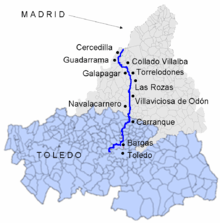
The Guadarrama is a river in Spain. A tributary of the Tagus, the longest river on the Iberian Peninsula, Guadarrama has its source in the Siete Peak, part of the Sierra de Guadarrama, in the Community of Madrid, in the central part of the country, at an altitude of 1,900 metres (6,200 ft).
Course
The Guadarrama flows from north to south for 131.80 kilometres (81.90 mi) through the autonomous community of Castilla-La Mancha and the Province of Toledo, where it empties into the Tagus.
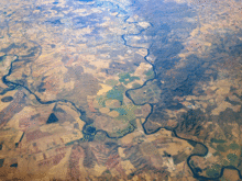
Its middle course is a protected area within the Regional Park of the Middle Course of the Guadarrama River and Its Surroundings (Spanish: Parque Regional del curso medio del río Guadarrama y su entorno), which is one of the three regional parks within the Community of Madrid.[1] The basin area is about 1,708 square kilometres (659 sq mi) Its main tributary is the Aulencia River, which flows entirely within the Community of Madrid and supplies water to the reservoir of Valmayor.
References
External links
-
 Media related to Guadarrama River at Wikimedia Commons
Coordinates: 39°52′55″N 4°10′09″W / 39.882052°N 4.169262°W