Háj, Turčianske Teplice District
| Háj | |
| Village | |
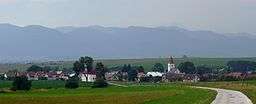 Háj general view | |
| Country | Slovakia |
|---|---|
| Region | Žilina |
| District | Turčianske Teplice |
| Coordinates | SK 48°52′N 18°53′E / 48.867°N 18.883°ECoordinates: SK 48°52′N 18°53′E / 48.867°N 18.883°E |
| Population | 478 (2004-12-31) |
| Founded | 1264 |
| Mayor | Jarmila Ižipová (HZDS) |
| Postal code | 039 01 |
| Area code | +421-0 43 |
| Car plate | TR |
  Location of Háj in Slovakia | |
  Location of Háj in the Žilina Region | |
| Statistics: MOŠ/MIS | |
Háj is a village and municipality in Turčianske Teplice District in the Žilina Region of northern central Slovakia.
History
In historical records the village was first mentioned in 1264.
Geography
The municipality lies at an altitude of 508 metres and covers an area of 9.332 km². It has a population of about 478 people.
Genealogical resources
The records for genealogical research are available at the state archive "Statny Archiv in Bytca, Slovakia"
- Roman Catholic church records (births/marriages/deaths): 1674-1896 (parish A)
- Lutheran church records (births/marriages/deaths): 1820-1923 (parish A)
See also
External links
Municipalities of Turčianske Teplice District | ||
|---|---|---|
This article is issued from Wikipedia - version of the 3/23/2016. The text is available under the Creative Commons Attribution/Share Alike but additional terms may apply for the media files.