Hörsel
For the municipality in Thuringia, see Hörsel, Thuringia.
| Hörsel | |
|---|---|
 The river Hörsel | |
| Country | Germany |
| Basin | |
| Main source | Thuringian Forest |
| River mouth |
Werra 51°0′30″N 10°13′45″E / 51.00833°N 10.22917°ECoordinates: 51°0′30″N 10°13′45″E / 51.00833°N 10.22917°E |
| Physical characteristics | |
| Length | 56 km (35 mi) |
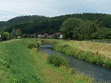
The Hörsel is a 56 km long river in Thuringia, Germany, right tributary of the Werra. It is formed by the confluence of two smaller rivers in Leinatal, at the northern edge of the Thuringian Forest. The Hörsel flows generally northwest through the towns Hörselgau, Wutha-Farnroda and Eisenach. It flows into the Werra in Hörschel, a village near Eisenach.
This article is issued from Wikipedia - version of the 5/26/2016. The text is available under the Creative Commons Attribution/Share Alike but additional terms may apply for the media files.