Habersham County Airport
| Habersham County Airport | |||||||||||
|---|---|---|---|---|---|---|---|---|---|---|---|
 | |||||||||||
| IATA: none – ICAO: KAJR – FAA LID: AJR | |||||||||||
| Summary | |||||||||||
| Airport type | Public | ||||||||||
| Owner/Operator | Habersham County | ||||||||||
| Serves | Cornelia, Georgia | ||||||||||
| Elevation AMSL | 1,448 ft / 441 m | ||||||||||
| Coordinates | 34°29′59″N 083°33′24″W / 34.49972°N 83.55667°W | ||||||||||
| Runways | |||||||||||
| |||||||||||
| Statistics (2009) | |||||||||||
| |||||||||||
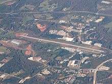
Habersham County Airport (ICAO: KAJR, FAA LID: AJR) is a county-owned public-use airport located two nautical miles (3.7 km) southwest of the central business district of Cornelia, in Habersham County, Georgia, United States.[1]
Although most U.S. airports use the same three-letter location identifier for the FAA and IATA, this airport is assigned AJR by the FAA but has no designation from the IATA.[2]
Facilities and aircraft
The airport covers an area of 133 acres (54 ha) at an elevation of 1,448 feet (441 m) above mean sea level. It has one asphalt paved runway designated 6/24 which measures 5,506 by 100 feet (1,678 x 30 m).[1]
For the 12-month period ending May 26, 2009, the airport had 16,000 aircraft operations, an average of 43 per day, all of which were general aviation. At that time there were 61 aircraft based at this airport: 88.5% single-engine, 9.8% multi-engine and 1.6% helicopter.[1]
References
- 1 2 3 4 FAA Airport Master Record for AJR (Form 5010 PDF). Federal Aviation Administration. Effective 3 June 2010.
- ↑ Great Circle Mapper: KAJR - Cornelia, Georgia - Hambersham County Airport
External links
- FAA Terminal Procedures for AJR, effective November 10, 2016
- Resources for this airport:
- FAA airport information for AJR
- AirNav airport information for AJR
- FlightAware airport information and live flight tracker
- SkyVector aeronautical chart for AJR