Hainberg (hills)
| Hainberg | |
|---|---|
 View from the Hunters' Tower (northern Jägerturmskopf) over the Hainberg | |
| Highest point | |
| Peak | Kalter Buschkopf |
| Elevation | 299 m (981 ft) |
| Dimensions | |
| Length | 15 km (9.3 mi) |
| Geography | |
| Country | Germany |
| State | Lower Saxony |
| Range coordinates | 52°02′N 10°12′E / 52.03°N 10.2°ECoordinates: 52°02′N 10°12′E / 52.03°N 10.2°E |
| Parent range | Lower Saxon Hills |
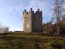
Jägerturm tower
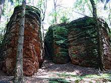
Part of the Bodenstein Crags
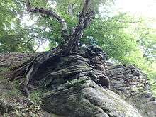
Rock formation at the Jägerhaus. Above: St Hubert's Chapel (and St. Hubert's Grotto)
The Hainberg (known locally as the Hainberge as it has several summits. Also the old form Heinberg) is a hill range, up to 299 metres high, northwest of the Harz Mountains in the eastern part of Lower Saxony, Germany.
Hills
Amongst the hills in the Hainberg are the following:
|
|
Settlements
Settlements in and near the Hainberg are:
|
This article is issued from Wikipedia - version of the 3/20/2016. The text is available under the Creative Commons Attribution/Share Alike but additional terms may apply for the media files.