Hakha
| Hakha Haka | |
|---|---|
|
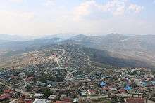
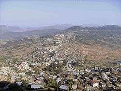
Hakha | |
 Hakha Location in Burma | |
| Coordinates: 22°38′43.9476″N 93°36′18.129″E / 22.645541000°N 93.60503583°ECoordinates: 22°38′43.9476″N 93°36′18.129″E / 22.645541000°N 93.60503583°E | |
| Country |
|
| State | Chin State |
| District | Hakha District |
| Township | Hakha Township |
| Area | |
| • Total | 12.50 sq mi (32.4 km2) |
| Elevation | 6,128 ft (1,867 m) |
| Population (2005) | |
| • Total | 50,000 |
| • Density | 4,000/sq mi (1,500/km2) |
| • Religions | Christian |
| Time zone | MST (UTC+6:30) |
Hakha (Burmese: ဟားခါးမြို့; MLCTS: ha: hka: mrui., pronounced: [hákʰá mjo̰]; formerly rendered Haka[1][2]) is the capital of Chin State in Burma.
It is located in the north-east in Chin State. The vernacular name of the city was Halkha. The total area of Hakha is about 12.50 square miles (32.4 km2). The town of Hakha is more than 1,800 meters (6,000 feet) above the sea level, founded on a small highland plateau, and although it is relatively small in land area, it is the largest town and capital city of the whole state and its plateau is significantly larger than that of other towns in Chin State. It is estimated that Hakha has enough land and full capacity to extend as much as ten times than its current township area. As Chin State is quite hilly, Hakha is built on the slope of a large mountain, in a U shape. There is only one main road running along the middle of the city, in a curve U, and the whole city is built along this road. Another road runs from the middle of the city, for a short while, forming the foot of U. Hakha is in the center of Chin State and it is connected with Thantlang, Falam, Gangaw and Matupi by truck roads.[3]
History
Hakha was founded around A.D. 1400 by the Lai ethnic group. The area was ruled by local chiefs for many generations and it consisted of more than 600 houses when the British troops arrived in Hakha in 1889.
The British occupied Hakha on January 19, 1890, as part of their operation to "subdue the wild tribes" in the Arakan Hills Division, as the area was then called. The British government later established a sub-divisional office and Hakha became a town a few years later.
The first American Baptist missionary couple, Arthur Carson (1860-1908) and his wife Laura (1858-1942) who arrived in Hakha on March 15, 1899 opened a mission station. Later other missionaries joined them and did extensive mission works throughout the Chin Hills and converted most of the Northern Chin State to Christianity within a century. This missionary work brought education, development, social and economic changes, and health improvement to the Chin people. The main contribution to language education was by Chester Strait of Wisconsin (1893-1985) who opened the Chin Hills Bible School in 1928 with thirteen students - four from the Tiddim area of the Zomi people, four from Falam and five from the Haka areas of the Laimi, another branch of the Chin people. Although the teaching was in the Lai language after six months all students were able to write their final exam in the language.[4]
During the Second World War, Hakha was captured by Japanese troops on November 11, 1943; it was later recaptured by British troops.
When Burma gained independence from British control in 1948, Hakha became an important city as the center for one of the subdivisions in the Chin Special Division, of which Falam was the capital at that time. The Chin Special Division was abolished reformed as the Chin State in 1974, at which time Hakha became the capital of the Chin State. That brought an influx of government workers, and housing development and extension of the city. Hakha eventually became the largest city in the Chin State with about 20,000 people. Hakha was part of the newly formed district:Hakha District on 1 June 2012.
Geography and climate
The city is 6,120 feet (1,870 m) above sea level and it lies at the foot of Rung Tlang (Mt. Rung), which is about 7,543 feet (2,299 m) high, and is one of the most famous and beautiful mountain peaks in the Chin State.
January is the coldest month of the year with a mean temperature of around 7 degrees Celsius. April is the hottest month at a mean of 36 degrees Celsius.
The total rainfall is about 86.22 inches every year.
It is quite cold during the winter months. Sometimes, the temperature drops to as low as minus two degree Celsius. It is also very windy in winter. The whole city is foggy in the morning and in the evening. The weather is excruciatingly cold. During the month of January, 2009 there was a cold wave that hit Burma. The government's mouth-piece newspaper, Myanma Ahlin,however, did not carry any story on the possible 'Cold Wave' passing through the country, though it mentioned that temperatures have dropped up to 0 degree in Hakha Town, capital city of Chin state in north-west Burma. According to medical experts, the 'Cold Wave' could cause severe health problems especially to children and elderly people and there are chances of some being paralyzed. Besides, cardiac and kidney problems could also grow worse.[5]
Burmese officials downplayed the warning issued by Indian officials. Tun Lwin, director of Burma's Department of Meteorology and Hydrology, said the cold spell was not unusual for this time of year."It is likely to be cold up until the end of the month but it is a regular cold season. It is not really anything new. There is no record breaking temperature," Tun Lwin said. The Burmese meteorology department has issued daily weather reports since 1988, but it has never issued warnings of predicted heat waves or cold snaps.[6]
Ministries and Government Organizations
http://www.myanmarteldir.com/government/other_gov.asp?id=13
Radio
Skynet Television
Culture
References
- ↑ Google Maps (Map). Google.
- ↑ Bing Maps (Map). Microsoft and Harris Corporation Earthstar Geographics LLC.
- ↑ "Hakha". Ilovemyanmar.org. Retrieved August 19, 2010.
- ↑ Lian H. Sakhong -In Search of Chin Identity: A Study in Religion, Politics and ... Page 171 2003 "Thus, he opened the Chin Hills Bible School at Haka on 1 May 1928 with thirteen students - four from the Tiddim area of the Zomi tribe, four from Falam and five from the Haka areas of the Laimi tribe. Although the teaching was in the Lai dialect ...
- ↑ "'Cold Wave' likely to sweep Burma". Mizzima.com. January 15, 2009. Retrieved August 19, 2010.
- ↑ http://english.dvb.no/news.php?id=2122. Retrieved February 10, 2009. Missing or empty
|title=(help)
External links
| Hakha test of Wikipedia at Wikimedia Incubator |
Capital: | |
|
Capital: Hakha | ||
| Falam District |  | |
| Hakha District | ||
| Mindat District | ||
| Cities and towns | ||