Hangers Way
| Hangers Way | |
|---|---|
| Length | 21 mi (34 km) |
| Location | Hampshire |
| Trailheads |
Alton 51°09′07″N 0°58′01″W / 51.152°N 0.967°W Queen Elizabeth Country Park 50°57′41″N 0°58′41″W / 50.9614°N 0.9781°W |
| Use | Hiking |
Hangers Way is a 21 mile long-distance footpath through Hampshire, England from Alton railway station to Queen Elizabeth Country Park.
The name Hanger comes from the Old English word hangra, meaning a steeply wooded slope.[1]
The footpath passes through Petersfield and Selborne along a series of steep-sided wooded hills, known as “The Hangers”, and can be walked in either direction.
The footpath is waymarked by metal and plastic disks found attached to wooden and metal posts, trees and street furniture. The waymarks are green and show a slope with a single tree.
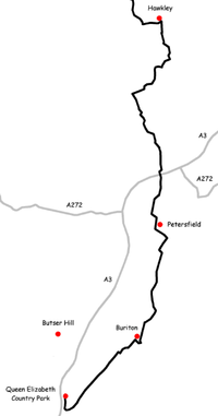
The route
These maps show the footpath in relation to nearby major roads and towns.

See also
References
External links
| Wikimedia Commons has media related to Hangers Way. |
This article is issued from Wikipedia - version of the 2/24/2015. The text is available under the Creative Commons Attribution/Share Alike but additional terms may apply for the media files.