Hanhowuz Reservoir
| Hanhowuz Reservoir | |
|---|---|
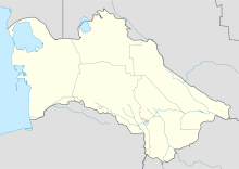
| Location | Mary Province |
| Coordinates | 37°13′56″N 61°14′37″E / 37.23222°N 61.24361°ECoordinates: 37°13′56″N 61°14′37″E / 37.23222°N 61.24361°E |
| Type | reservoir |
| Basin countries | Turkmenistan |
Hanhowuz, also known as Khauz-Khan is a reservoir in Mary Province of southeastern Turkmenistan. It is located at 37°13′56″N 61°14′37″E / 37.23222°N 61.24361°E. The M37 highway passes nearby and the village of Hanhowuz stands on the northwestern shore, with the city of Tejen not too far away in that direction.
Hanhowuz Reservoir is a component of the Kara Kum Canal system and it was created to attempt to control the erratic Tejen River. It plays an important role in agriculture in the region.[1] The reservoir was named after Oguz Han.
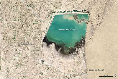
Hanhowuz (Khauzkhan) Reservoir was constructed in a natural depression to capture winter runoff and overflow from the canal for use later during the driest periods of summer. Phytoplankton thrive in the warm waters, as do many commercial fish—including Aral barbel, asp and catfish.
In the satellite image, Garagum Canal is the brown ribbon dropping down from the upper right corner and heading south and east from the reservoir. A portion of the canal is diverted, and you can see the brown sediment-laden water entering the reservoir from the east and dropping its load of suspended sediments. The water that leaves is turquoise and travels west to irrigate the Tedjen Oasis. Roughly rectilinear farmlands appear on either side of that section of the canal.[2]
References
- ↑ Brummell, Paul (2006). Bradt Travel Guide Turkmenistan. Bradt Travel Guides. p. 220. ISBN 1-84162-144-7.
- ↑ Hanhowuz Reservoir at NASA Earth Observatory