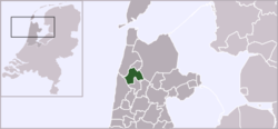
Harenkarspel
| Harenkarspel | |||
|---|---|---|---|
| Former municipality | |||
 | |||
| |||
 | |||
| Coordinates: 52°44′N 4°45′E / 52.73°N 4.75°ECoordinates: 52°44′N 4°45′E / 52.73°N 4.75°E | |||
| Country | Netherlands | ||
| Province | North Holland | ||
| Municipality | Schagen | ||
| Area(2006) | |||
| • Total | 54.83 km2 (21.17 sq mi) | ||
| • Land | 54.03 km2 (20.86 sq mi) | ||
| • Water | 0.80 km2 (0.31 sq mi) | ||
| Population (1 January 2007) | |||
| • Total | 15,922 | ||
| • Density | 295/km2 (760/sq mi) | ||
| Source: CBS, Statline. | |||
| Time zone | CET (UTC+1) | ||
| • Summer (DST) | CEST (UTC+2) | ||
| Website | www.harenkarspel.nl | ||

Harenkarspel (![]() pronunciation ) is a former municipality in the Netherlands, in the province of North Holland and the region of West-Frisia. The main town of Harenkarspel was Tuitjenhorn. In 2013, Harenkarspel merged with Schagen and Zijpe into a new municipality, which is called Schagen.
pronunciation ) is a former municipality in the Netherlands, in the province of North Holland and the region of West-Frisia. The main town of Harenkarspel was Tuitjenhorn. In 2013, Harenkarspel merged with Schagen and Zijpe into a new municipality, which is called Schagen.
Population centres
The former municipality of Harenkarspel consisted of the following villages: Dirkshorn, Eenigenburg, Groenveld, Kalverdijk, Kerkbuurt, Krabbendam, 't Rijpje, Schoorldam (partly), Sint Maarten, Stroet, Tuitjenhorn, Valkkoog, Waarland, and Warmenhuizen. The largest towns were Warmenhuizen and Tuitjenhorn. The town hall of Harenkarspel was located in Tuitjenhorn.
Local government
The municipal council of Harenkarspel consisted of 17 seats, which were divided as follows:
References
- Statistics are taken from the SDU Staatscourant
External links
| Wikimedia Commons has media related to Harenkarspel. |
- A map of the former municipality of Harenkarspel
- City Site (Dutch)
- Nieuws over Harenkarspel (Dutch)
- Alles over Schagen FM, de lokale omroep voor Schagen, Zijpe, Niedorp en Harenkarspel (Dutch)
This article is issued from Wikipedia - version of the 6/21/2013. The text is available under the Creative Commons Attribution/Share Alike but additional terms may apply for the media files.