Harker Canyon (Tooele County, Utah)
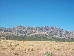
Harker Canyon is located 10 km (6.2 mi) south of the town of Vernon, in Tooele County, Utah, USA. The canyon is oriented east-west on the southern side of the Sheeprock Mountains, a small mountain group in the larger Wasatch Range.[1] The canyon is entirely encompassed by the boundaries of the Wasatch-Cache National Forest, and is accessible from Harker Road by a forest road designated NF 586. There are many abandoned mines in the canyon. Bird watching and horseback riding are popular recreational activities in the canyon.
History
Harker Canyon has been extensively mined for hard minerals. Artifacts of a ghost town and abandoned mining operations below a natural spring remain. Management of the old mines is assigned to the Vernon Sheeprocks Project, a joint project managed by the United States Forest Service, the United States Department of Agriculture, the United States Department of the Interior, and the Utah Department of Natural Resources. In a report issued in January, 2005, Harker Canyon was singled out as having the highest concentrations of heavy metals in its groundwater of any sampled area in the Sheeprock Mountains.[2] Harker Canyon is located in the Utah Division of Wildlife Resources Wildlife Management Unit 19B.[3]
Geography
Harker Canyon is about 5.0 km (3.1 mi) long. The road entrance to the canyon at its eastern end is at approximately 1,900 m (6,300 ft) elevation, and the top of the canyon at its western end is at about 2,700 m (8,800 ft) elevation above sea level. A natural spring can be found in the canyon at 2,255 m (7,400 ft) elevation, which flows into Harker Creek. Vegetation in the canyon is principally a pinyon-juniper woodland.
References
- ↑ United States Geological Survey (2007). "Feature Detail Report: Harker Canyon". Geographic Names Information System. Retrieved July 23, 2007.
- ↑ Rohrer, J. Chirs and Resare, Duane (2005). Environmental Assessment: Vernon Sheeprocks Project. U.S. Department of Agriculture, U.S. Forest Service, U.S. Department of the Interior, State of Utah Department of Natural Resources. January, 2005. p. 22.
- ↑ Utah Division of Wildlife Resources (2006). "Wildlife Management Unit 19B - West Desert, Vernon". Utah Big Game Range Trend Studies. Retrieved Aug. 16, 2006.
External links
- Harker Canyon - Ghost Towns and History of the American West
- Harker Canyon Photographs from 1997 to 2002 - Utah Division of Wildlife Resources
Coordinates: 39°59′27″N 112°28′20″W / 39.9908°N 112.4722°W