Harome
| Harome | |
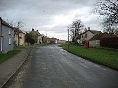 The main street in the village of Harome heading eastwards |
|
 Harome |
|
| Population | 261 (2011 census) |
|---|---|
| Civil parish | Harome |
| District | Ryedale |
| Shire county | North Yorkshire |
| Region | Yorkshire and the Humber |
| Country | England |
| Sovereign state | United Kingdom |
| Post town | YORK |
| Dialling code | 01439 |
| Police | North Yorkshire |
| Fire | North Yorkshire |
| Ambulance | Yorkshire |
| EU Parliament | Yorkshire and the Humber |
| UK Parliament | Thirsk and Malton |
Coordinates: 54°13′00″N 1°00′00″W / 54.216667°N 1.00°W
Harome is a small village and civil parish in the Ryedale district of North Yorkshire, England, around 2 miles south-east of the market town of Helmsley, and 24 miles north-east of York.[1] The village has a population of 261 people according to the 2011 UK census,[2] and a total land area of 9,539 sq metres.[3] It is situated to the east of the River Riccal.[4] The village has 109 households, with agriculture and retail trade being the two main employers for the residents.[5] The name Harome simply means rocks/stones, and translates from old English meaning a heap of stones.[6]
History
Until the nineteenth century, the village was known as Harum. By 1900 it had transitioned through Harom to its modern-day name of Harome.
In the 1870s, Harome was described as:
- "HARUM, or HAROME, a chapelry in Helmsley parish, N. R. Yorkshire; on the rivers Rye and Riccal, 2 miles SE by E of Helmsley, and 4 N of Hovingham r. station. Post town, Helmsley, under York. Acres, 2, 303. Real property, £3, 093. Pop., 447. Houses, 90."[7] – John Marius Wilson (1870–72)

According to the UK census information, the population of Harome has decreased from 439 people in 1881 to 269 people between 1881 and 1961.[8] More recently, the population has shown to be continually decreasing following the 2001 UK census falling to 252 people,[9] however the 2011 census has shown an increase to 261 people- the first population increase since 1901.[10]
Construction of the local church began in May 1861, on the site of a previously demolished building. St Saviour church was completed in August 1862, under the patronage of the Feversham Estate. The architect was Charles Barry Jr, whose father designed the Houses of Parliament. It was originally furnished by William Duncombe, who represented the North Riding of Yorkshire as a member of parliament between 1859 and 1867. The church contains glass from Hardman, and most recently a Millennium Cross produced by a local craftsman.[11] Until 1863 Harome had been part of the parish of Helmsley.[12]
Harome Methodist Church was built in 1909.[13]
Industry
The 1881 UK census recorded that Harome's industry was predominately agriculturally based, with a total of 73 people working within agriculture, 71 of these were men. Domestic services was the second most popular occupation, with 15 people in total. There were also people within the parish who worked in other occupations such as dressmakers, textile fabrics and food and lodging, to name a few.[14] The village also has a listed water mill dating back to the late eighteenth century.[15]
In recent times the residents of Harome have shifted away from more agriculturally based occupations, which has been shown in the UK 2011 census. However, skilled trades is still the most popular occupation throughout the parish, with 36 people within this line of work. A lot of people are now predominately within a tertiary and quaternary based job, these include managers and directors, along with science researchers.[16]
Housing and transport
Harome is a quaint village with several listed buildings along a wide main street.[17]
Harome has most recently been categorised as being a 'village surrounded by sparsely populated countryside' by the Office for National Statistics.[18] The housing within Harome is typically detached and terraced housing, with the average house price for a detached house at £269,371.[19]
There are 183 vehicles within Harome, with 52.3% of the population accounting for 2 or more cars or vans.[20] There are 4 bus routes serving Harome, all are school services.[21] The nearest railway station to Harome is Malton railway station, which is located 10.84 miles away.[22]
Geography
Harome is located at 54° 13′ 0″ N, 1° 0′ 0″ W (54.216667, −1). According to the Office for National Statistics, the Parish had a total land area of 9,539 sq metres, of which 9,113.61 is areas of green space and 86.93 sq metres is areas of water.[23] The River Riccal runs to the west of Harome, which is met by many tributaries from the North York Moors, and runs through into the North Sea. Harome is situated 18.2 miles north-east from York, and 191 miles north from London.[24]
Climate
Harome has a Maritime Temperate climate (Köppen climate classification Cfb) typical to the United Kingdom, characterised by cool summers and mild winters, due to a changeable and often overcast weather.
| Climate data for Harome | |||||||||||||
|---|---|---|---|---|---|---|---|---|---|---|---|---|---|
| Month | Jan | Feb | Mar | Apr | May | Jun | Jul | Aug | Sep | Oct | Nov | Dec | Year |
| Average high °C (°F) | 8 (46) |
8 (46) |
10 (50) |
13 (55) |
16 (61) |
19 (66) |
21 (70) |
21 (70) |
18 (64) |
14 (57) |
10 (50) |
7 (45) |
13.8 (56.7) |
| Average low °C (°F) | 1 (34) |
1 (34) |
2 (36) |
3 (37) |
6 (43) |
9 (48) |
11 (52) |
11 (52) |
9 (48) |
6 (43) |
3 (37) |
1 (34) |
5.3 (41.5) |
| Average precipitation mm (inches) | 53 (2.09) |
34 (1.34) |
43 (1.69) |
56 (2.2) |
49 (1.93) |
69 (2.72) |
55 (2.17) |
69 (2.72) |
44 (1.73) |
64 (2.52) |
56 (2.2) |
53 (2.09) |
645 (25.4) |
| Source: [25] | |||||||||||||
References
- ↑ "Distance of Harome to Helmsley and York". Free Map Tools- Harome. Retrieved 22 April 2013.
- ↑ "Key Figures for 2011 Census: Key Statistics: Harome". Neighbourhood Statistics. The Office for National Statistics. Retrieved 7 March 2013.
- ↑ "Land use statistics (Generalised land use datebase)". Retrieved 22 February 2013.
- ↑ "The River Riccas". British History Online. A History of the County of York East Riding: Volume 3: Ouse and Derwent wapentake, and part of Harthill wapentake. Retrieved 22 April 2013.
- ↑ "Parish profile-households, 2001". Retrieved 22 February 2013.
- ↑ "Key to English place-names: Harome". University of Nottingham- Institute for name studies. Retrieved 7 March 2013.
- ↑ Wilson, John (1870–72). "Imperial Gazetteer of England and Wales" (1st ed.). Edinburgh: A. Fullarton and Co. Retrieved 4 February 2013.
- ↑ "Population of Harome (Parish): 1881–1961". A vision of Britain through time. Vision of Britain. Retrieved 7 March 2013.
- ↑ "Key Figures for 2001 Census: Key Statistics". Neighbourhood Statistics. Office for National Statistics. Retrieved 7 March 2013.
- ↑ "Key Figures for 2011 Census: Key Statistics". Neighbourhood Statistics. Office for National Statistics. Retrieved 7 March 2013.
- ↑ "Helmsley History and heritage: St Saviour's Church". Retrieved 4 February 2013.
- ↑ "Parishes: Helmsley - British History Online". www.british-history.ac.uk. Retrieved 17 August 2016.
- ↑ "Harome Methodist Church". www.harome.ryedalemethodist.org.uk. Retrieved 17 August 2016.
- ↑ "1881 Occupational orders: Harome". Vision of Britain. Retrieved 7 March 2013.
- ↑ "Harome Mill and Millhouse and Lamp Post Approximately Eight Metres South of House - Harome - North Yorkshire - England | British Listed Buildings". www.britishlistedbuildings.co.uk. Retrieved 17 August 2016.
- ↑ "Occupation (Minor Groups), 2011". Neighbourhood Statistics. Office for National Statistics. Retrieved 7 March 2013.
- ↑ "Listed Buildings in Harome, North Yorkshire, England". www.britishlistedbuildings.co.uk. Retrieved 17 August 2016.
- ↑ "Socio-demographic data-Harome". British Streets. Retrieved 7 March 2013.
- ↑ "House prices and council tax: Harome, Ryedale". UK Local Area. Retrieved 7 March 2013.
- ↑ "Car or Van Availability, 2011". Neighbourhood Statistics. The Office for National Statistics. Retrieved 7 March 2013.
- ↑ "Bus routes serving Harome". North Yorks Travel. Retrieved 7 March 2013.
- ↑ "Nearest Station: Harome Ryedale". UK Local Area. Retrieved 7 March 2013.
- ↑ "Land Use Statistics for Harome". Neighbourhood Statistics. Office for National Statistics. Retrieved 18 March 2013.
- ↑ "Location of Harome". Earth Tools. Earth Tools. Retrieved 18 March 2013.
- ↑ "Harome Climate History". weather2. Retrieved 18 March 2013.
External links
![]() Media related to Harome at Wikimedia Commons
Media related to Harome at Wikimedia Commons