Hase
For other uses, see Hase (disambiguation).
| Hase | |
| River | |
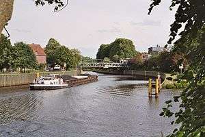 The canalized mouth of the river in Meppen | |
| Name origin: haswa, germanic for gray | |
| Country | Germany |
|---|---|
| Bundesland | Lower Saxony |
| Tributaries | |
| - right | Südradde, Mittelradde |
| Cities | Meppen (mouth), Haselünne, Herzlake, Löningen, Essen (Oldenburg), Quakenbrück, Bersenbrück, Bramsche, Osnabrück, Wellingholzhausen (source) |
| Source | |
| - location | Melle-Wellingholzhausen, Teutoburg Forest |
| - elevation | 165 m (541 ft) |
| - coordinates | 52°7′56.66″N 8°15′52.83″E / 52.1324056°N 8.2646750°E |
| Mouth | Ems River |
| - location | Meppen |
| - elevation | 15 m (49 ft) |
| - coordinates | 52°41′27.82″N 7°17′48.14″E / 52.6910611°N 7.2967056°ECoordinates: 52°41′27.82″N 7°17′48.14″E / 52.6910611°N 7.2967056°E |
| Length | 169.649 km (105 mi) |
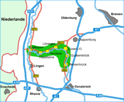 Course of the Hase through the Hase Valley | |
The Hase is a 193-kilometre (120 mi) long river in Lower Saxony, Germany. It is a right tributary of the Ems, but part of its flow goes to the Else, that is part of the Weser basin. Its source is in the Teutoburg Forest, south-east of Osnabrück, on the north slope of the 307-metre (1,007 ft) high Hankenüll hill.
Weser-Ems watershed
After about 15 kilometres (9 mi), near Gesmold and about 6 kilometres (4 mi) west of Melle, the Hase encounters an anomaly of terrain and bifurcates such that each branch flows in a different drainage system:
- one third of its waters flow along the south side of the Wiehengebirge hills eastward from Gesmold into the Else, which begins there, and flows into the Werre at Kirchlengern (north of Herford). The Werre is a tributary of the Weser.
- two thirds of its waters (the Hase proper) flow northwest from Gesmold toward Osnabrück, past the towns listed below, and toward Meppen, where the Ems receives its flow.
Towns
- Melle
- Bissendorf
- Osnabrück
- Bramsche - to the south of this city the Hase crosses the Mittellandkanal
- Neuenkirchen-Vörden
- Bersenbrück
- Badbergen
- Quakenbrück - in the southeast the Hase divides into two branches: the Big Hase (passing the town in the northeast) and the Little Hase (which itself is divided into several branches within the town, one of which leaves the town northwards to the Big Hase) (Binnendelta)
- Menslage - here the Hase is channeled into the Little Hase
- Löningen - here it flows into a somewhat northerly branch: the Big Hase
- Herzlake - here the two branches flow together again
- Haselünne
- Meppen
| Wikimedia Commons has media related to Hase. |
This article is issued from Wikipedia - version of the 8/24/2015. The text is available under the Creative Commons Attribution/Share Alike but additional terms may apply for the media files.