Hasenhorn
| Hasenhorn | |
|---|---|
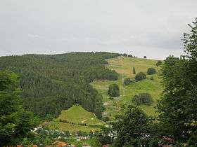 Hasenhorn - view from the refuge hut above the church of St. John the Baptist | |
| Highest point | |
| Elevation | 1,156 m (3,793 ft) |
| Coordinates | 47°49′16.6″N 07°57′6.54″E / 47.821278°N 7.9518167°ECoordinates: 47°49′16.6″N 07°57′6.54″E / 47.821278°N 7.9518167°E |
| Geography | |
 Hasenhorn | |
| Parent range | Southern Black Forest |
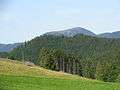
The Hasenhorn is a mountain, 1,155.6 m above sea level (NHN)[1], in the Southern Black Forest in Germany. The mountain lies southeast of the little town of Todtnau.
In 2004, the old single chairlift on the Hasenhorn was removed and replaced by modern double chairlift. At the same time an all-weather toboggan run (Rodelbahn) was built on the Hasenhorn, at the time the longest of its kind in Germany. The run is owned by an investor who also owns the Steinwasen Park. In addition, on the Hasenhorn there are suitable downhill runs and, in winter, a prepared toboggan run. In the vicinity of the chairlift's top station is a restaurant, the Berggasthaus Hasenhorn.
-
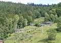
The all-weather toboggan run
-
The Hasenhorn and its tower (seen from the Gisibodenalm)
-
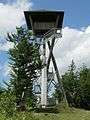
The Hasenhorn Tower
References
External links
- Badische Seiten: Hasenhorn
- Todtnauer Ferienland: Ausflugsziele
- Hasenhorn Coasterbahn
- Lift databank Hasenhorn
- Description of the Hasenhorns at Badische Seiten.de