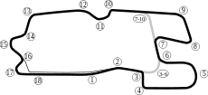
Heartland Park Topeka
  | |
| Location | Topeka, Kansas, United States of America |
|---|---|
| Time zone | GMT-6 |
| Owner | Shelby Development LLC (Chris Payne & Todd Crossley) |
| Opened | 1989 |
| Major events |
National Hot Rod Association NHRA Kansas Nationals |
| Grand Prix Road Course | |
| Surface | Asphalt |
| Length | 2.5 mi (4 km) |
| Turns | 14 |
| Clay Oval | |
| Surface | Clay |
| Length | .375 mi (.6 km) |
| Turns | 4 |
| Dragstrip | |
| Surface | Asphalt |
| Lap record | 0:3.676 (Brittany Force, John Force Racing, 2016, NHRA Top Fuel Dragster) |
| Motocross track | |
| Surface | Dirt |
Heartland Park Topeka is a multi-purpose motorsports facility located 5 miles (8 km) south of Topeka, Kansas.
When it opened in 1989,[1] it was the first brand-new auto racing facility to be built in the United States for 20 years. Its facilities include a road-race course with 4 possible configurations (ranging from 1.8 miles (2.9 km) to 2.5 miles (4.0 km) in length), a ⅜ mile clay oval, off-road course and a ¼ mile drag strip. After several years of neglect, owing to continual financial difficulties, the track surface and other facilities had deteriorated badly and the very survival of the track was in doubt. In 2003, it was bought by Raymond Irwin, former owner (2007) of Blackhawk Farms Raceway, who has instituted a program of major renovations to the facility.[1]
In January 2016, the track was purchased by Chris Payne and Todd Crossley of Shelby Development, LLC.
The drag-strip is used by local clubs and the National Hot Rod Association. The road-course is mainly used by the SCCA, the National Auto Sport Association and marque-clubs. The track was the home of both the SCCA National Championship Runoffs and the Tire Rack SCCA Solo National Championships from 2006 to 2008. In the past, it has hosted ARCA, ASA, IMSA, AMA and the NASCAR Craftsman Truck Series' O'Reilly Auto Parts 275.[1]
References
- 1 2 3 Peterson, Rick (May 25, 2003). "'Special times': Heartland Park has attracted racing legends". The Topeka Capital-Journal. Topeka, KS. Retrieved 2014-03-27.
External links
- Official website
- Heartland Park Topeka race results at Racing-Reference
- Trackpedia guide to driving this track
Coordinates: 38°55′29″N 95°40′26″W / 38.92472°N 95.67389°W