Heitersheim
| Heitersheim | |||
|---|---|---|---|
| |||
 Heitersheim | |||
Location of Heitersheim within Breisgau-Hochschwarzwald district 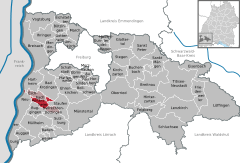
 | |||
| Coordinates: 47°52′31″N 7°39′17″E / 47.87528°N 7.65472°ECoordinates: 47°52′31″N 7°39′17″E / 47.87528°N 7.65472°E | |||
| Country | Germany | ||
| State | Baden-Württemberg | ||
| Admin. region | Freiburg | ||
| District | Breisgau-Hochschwarzwald | ||
| Government | |||
| • Mayor | Jürgen Ehret (CDU) | ||
| Area | |||
| • Total | 11.71 km2 (4.52 sq mi) | ||
| Population (2015-12-31)[1] | |||
| • Total | 6,139 | ||
| • Density | 520/km2 (1,400/sq mi) | ||
| Time zone | CET/CEST (UTC+1/+2) | ||
| Postal codes | 79423 | ||
| Dialling codes | 07634 | ||
| Vehicle registration | FR | ||
| Website | www.heitersheim.de | ||


Heitersheim is a town in the district Breisgau-Hochschwarzwald, Baden-Württemberg in southern Germany. The name of the school located in Heitersheim is Johanniterschule.
Geography
The city is located in Markgräflerland in South Baden. The city contains older central part Heiterscheim and newer Gallenweiler.
History
- 777. The city is mentioned for the first time in Lorscher codex
- 1810. The becomes a city
- 1847. Railway Freiburg - Basel passes through city
- 1971. Unification with Gallenweiler
Partner cities
The Austrian town of Vandans is the sister city of Heitersheim since 1991.
See also
References
This article is issued from Wikipedia - version of the 6/21/2015. The text is available under the Creative Commons Attribution/Share Alike but additional terms may apply for the media files.