Helmsley railway station
| Helmsley | |
|---|---|
|
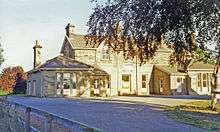
Helmsley railway station in 2006 | |
| Location | |
| Place | Helmsley |
| Area | Ryedale |
| Coordinates | 54°14′40″N 1°03′14″W / 54.244461°N 1.053900°WCoordinates: 54°14′40″N 1°03′14″W / 54.244461°N 1.053900°W |
| Grid reference | SE617836 |
| Operations | |
| Pre-grouping | North Eastern Railway (UK) |
| Platforms | 2 |
| History | |
| 1871[1] | opened |
| 1953 | closed |
| 10 August 1964 | closed for freight |
| Disused railway stations in the United Kingdom | |
|
Closed railway stations in Britain A B C D–F G H–J K–L M–O P–R S T–V W–Z | |
|
| |
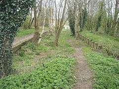
The station buildings in 1995
Helmsley railway station served the market town of Helmsley in North Yorkshire from 1871 until 1964, although the regular passenger service (and the line from Kirkbymoorside east to Pickering) ceased in 1953.
From here to Pickering the line ran almost parallel to today's A170 trunk road.
There was no railway over the area between Helmsley and Thirsk via Sutton Bank. Instead, there was a route south of Helmsley that passed through a cutting at Caulkeys Bank, Nunnington, and then turned west towards Gilling, where the Thirsk and Malton (T&M) Line from Pilmoor (at the East Coast Main Line) was met. To get to Thirsk, trains would have had to travel to Gilling and Pilmoor first, turning north.
References
External links
| Preceding station | Disused railways | Following station | ||
|---|---|---|---|---|
| Nunnington | Gilling and Pickering (G&P) Line | Nawton | ||
This article is issued from Wikipedia - version of the 8/20/2016. The text is available under the Creative Commons Attribution/Share Alike but additional terms may apply for the media files.