Henricus Martellus Germanus
Henricus Martellus Germanus is the latinized name of Heinrich Hammer (Italian: Enrico Martello), a geographer and cartographer from Nuremberg who lived and worked in Florence from 1480 to 1496.
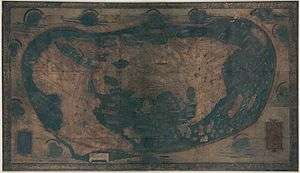
Between around 1489 and 1491, he produced at least one world map which is remarkably similar to the terrestrial globe produced by Martin Behaim around 1492, the Erdapfel. Both show novel adaptions of the existing Ptolemaic model, opening a passage south of Africa and creating an enormous new peninsula east of the Golden Chersonese (Malaysia). Both possibly derive from maps created around 1485 in Lisbon by Bartolomeo Columbus.
The only extant manuscript world map, measuring 201 cm x 122 cm in size, was rediscovered in 1960 and donated to Yale's Beinecke Rare Book and Manuscript Library.[1]
Martellus also produced an Insularium Illustratum ("Illustrated Book of Islands") of which four manuscripts are extant, plus one draft in Biblioteca Laurentiana. It contains an illustrated description of islands of the Aegean Sea, mostly copied from a previous work by Cristoforo Buondelmonti, plus maps from other islands, several regional maps and a world map.[2]
He has been identified with an Arrigho di Federigho who authored the first translation into German of Bocaccio's Decamerone. According to this theory, the surname Martellus would come from the Martelli family, to which Henricus / Arrigho was linked.[3]
References
- ↑
- ↑ Bouloux, Nathalie (2012). "L'Insularium Illustratum d'Henricus Martellus". The Historical Review / La Revue Historique. IX: 77–94. Retrieved 30 September 2016.
- ↑ Rezension von L. Böninger: Die deutsche Einwanderung nach Florenz (2006)
External links
| Wikimedia Commons has media related to Henricus Martellus Germanus. |
- Arthur Davies: Behaim, Martellus and Columbus, The Geographical Journal, Vol. 143, No. 3 (Nov., 1977), pp. 451-459
- Alexander O. Vietor: A Pre-Columbian Map of the World, Circa 1489, Imago Mundi, Vol. 17, 1963 (1963), pp. 95-96
- An essay on the world maps created by Henricus Martellus Germanus
- Recent findings via multispectral imaging: presentation by Chet van Duzer, Hidden secrets of Yale’s 1491 world map revealed via multispectral imaging press release by Yale University.