Arkansas Highway 129
| ||||
|---|---|---|---|---|
 | ||||
| Route information | ||||
| Maintained by AHTD | ||||
| Existed: | 1928 – present | |||
| Section 1 | ||||
| Length: | 15.02 mi[1] (24.17 km) | |||
| South end: |
| |||
| North end: |
| |||
| Section 2 | ||||
| Length: | 4.30 mi[1] (6.92 km) | |||
| South end: |
| |||
| North end: |
| |||
| Location | ||||
| Counties: | Union | |||
| Highway system | ||||
| ||||

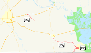
Highway 129 (AR 129, Ark. 129, and Hwy. 129) is a designation for two north–south state highways in Union County. An southern route of 15.02 miles (24.17 km) runs north from Louisiana Highway 33 (LA 33) at the Louisiana state line to US Route 82 (US 82) in Strong.[2] A second route of 4.30 miles (6.92 km) begins at US 63 and runs south to Lawson.[2]
Route description
Louisiana to Strong
From the south, Highway 129 begins as a continuation of LA 33 at the state line. Heading north, Highway 129 produces a business route, Highway 129B, which serves the residential areas of Huttig. After about 9 miles (14 km), Highway 129 joins with Highway 275, running concurrently until an intersection with US 82 terminates Highway 129. AR 275 continues north to US 63.
AR 129 is an undivided, two-lane road for its entire route.
US 63 to Lawson
Highway 129 begins at US 63 at Old Union and runs southeast to Union County Road 185 at Lawson.[2] A 2010 study of annual average daily traffic (AADT) by the Arkansas State Highway and Transportation Department (AHTD) reveals that about 500 vehicles use the daily basis around Lawson, and around 1,000 vehicles per day use the road near the northern terminus.[1]
History
Highway 129 first shows up on the 1928 Arkansas state highway map as a short route from the Louisiana state line to State Road 2 in Huttig.[3] The route was later extended to Strong around 1930 as State Road 2 was rerouted through Crossett.[4] The short segment to Lawson was added between 1965 and 1966 and remains along the original alignment today.[5][6]
Major intersections
The entire route is in Union County.
| Location | mi[1] | km | Destinations | Notes | |||
|---|---|---|---|---|---|---|---|
| | 0.00 | 0.00 | Southern terminus | ||||
| | 2.52 | 4.06 | Southern end of AR 129B | ||||
| | 2.95 | 4.75 | Northern end of AR 129B | ||||
| | 13.86 | 22.31 | Begin AR 275 concurrency | ||||
| Strong | 15.02 | 24.17 | Northern terminus | ||||
| Gap in route | |||||||
| Old Union | 0.00 | 0.00 | Northern terminus | ||||
| Lawson | 4.30 | 6.92 | Southern terminus | ||||
| 1.000 mi = 1.609 km; 1.000 km = 0.621 mi | |||||||
Huttig business route
| |
|---|---|
| Location: | Huttig |
| Length: | 2.24 mi[1] (3.60 km) |
Highway 129 Business (AR 129B, Ark. 129B, and Hwy. 129B) is a north–south state highway business route at Huttig. The route of 2.24 miles (3.60 km) serves to connect Huttig to the state highway system.[2]
- Major intersections
The entire route is in Union County.
| Location | mi[1] | km | Destinations | Notes | |
|---|---|---|---|---|---|
| | 0.00 | 0.00 | Southern terminus | ||
| | 2.24 | 3.60 | Northern terminus | ||
| 1.000 mi = 1.609 km; 1.000 km = 0.621 mi | |||||
See also
 Arkansas portal
 U.S. Roads portal
References
- 1 2 3 4 5 6 Planning and Research Division (March 28, 2012). "Arkansas Road Log Database" (MBD). Arkansas State Highway and Transportation Department. Retrieved April 13, 2012.
- 1 2 3 4 General Highway Map, Union County, Arkansas (PDF) (Map). 1:62500. Cartography by Planning and Research Division. Arkansas State Highway and Transportation Department. June 11, 2010. Retrieved April 14, 2012.
- ↑ Map of State of Arkansas Showing System of State Highways (Map). Little Rock, Arkansas: State Highway Department. September 1, 1928. Archived from the original (TIF) on 2011-10-13.
- ↑ Official Highway Service Map (Map). Little Rock, Arkansas: State Highway Department. March 1930. Archived from the original (TIF) on 2011-07-07.
- ↑ 1965 Highway Map of Arkansas (Map). Little Rock, Arkansas: Arkansas State Highway Department. 1965. Archived from the original (TIF) on 2011-07-07.
- ↑ 1966 Highway Map of Arkansas (Map). Little Rock, Arkansas: Arkansas State Highway Department. 1966. Archived from the original (TIF) on 2012-05-14.