Highway M07 (Ukraine)
| |
|---|---|
| Автошлях M07 | |
 | |
| Route information | |
| Length: |
486.5 km (302.3 mi) 488.4 km (303.5 mi) with access roads |
| Major junctions | |
| East end: |
(Kiev) |
|
(Kovel) | |
| West end: |
(Yahodyn) |
| Location | |
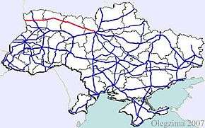
| Regions: | Kiev, Kiev Oblast, Zhytomyr Oblast, Rivne Oblast, Volyn Oblast |
| Highway system | |
| Roads in Ukraine | |
![]() is a Ukrainian international highway (M-highway) connecting Kiev to Yahodyn on the border with Poland, where it connects to Polish regional road 12.[1][2]
is a Ukrainian international highway (M-highway) connecting Kiev to Yahodyn on the border with Poland, where it connects to Polish regional road 12.[1][2]
In Soviet times, ![]() was identified as A255. Today,
was identified as A255. Today, ![]() stretches through four oblasts and ends at the border checkpoint Yahodyn in Liuboml Raion (Volyn Oblast).
stretches through four oblasts and ends at the border checkpoint Yahodyn in Liuboml Raion (Volyn Oblast).
Route
| Highway M07 | |||
| Marker | Main settlements | Notes | Highway Interchanges |
|---|---|---|---|
| 0 km | Kiev | ||
| Kovel | |||
| 486 km | Yahodyn / Border (Poland) | ||
Gallery
-
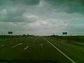
M07 Highway near Lyuboml'
-

M07 in Volyn Oblast
See also
References
External links
- International Roads in Ukraine in Russian
- European Roads in Russian
| E-roads in Ukraine | ||
|---|---|---|
| International | ||
| National | ||
| Regional |
| |
| ||
This article is issued from Wikipedia - version of the 6/3/2015. The text is available under the Creative Commons Attribution/Share Alike but additional terms may apply for the media files.