Hindutash

| Hindutash Pass | |
|---|---|
| Elevation | 5,450 m (17,881 ft) |
| Location |
|
| Range | Kunlun Mountains |
| Coordinates | 36°16′23″N 78°46′50″E / 36.27306°N 78.78056°ECoordinates: 36°16′23″N 78°46′50″E / 36.27306°N 78.78056°E |
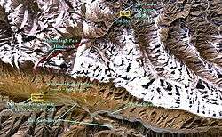
Hindutash, also known as Hindu-tagh Pass, is a historical mountain pass in the western Xinjiang Uyghur Autonomous Region (formerly, Chinese Turkestan) of the People's Republic of China. The pass cuts through the Kunlun Mountains connecting the now-deserted town of Kangxiwar, formerly Kengshewar, (36° 11' 58 N, 78° 46' 50 E) in the Karakash River valley to the town of Pusha, (36.3833° N, 79° E), formerly Bushia, in the Yurungkash River valley, and also connects to the road to the city of Hotan, formerly Khotan.[1] (See maps on right.)
A recent detailed Chinese map labels the pass 印地他什达坂 (Yìndì-Tāshí Dábǎn), and shows only a "track", but no road, going over it. The same map showed no other roads or tracks crossing the Kunlun within Hotan County.[2]
History
In 1857, the explorer Robert Schlagintweit crossed this pass from camping grounds in Sumgal ("three fords"), on the banks of the Karakash river, approximately 7 miles (11 km) upstream from Kengshewar and estimated its height to be 17,879 ft (5,450 m). At the top of the pass (36° 16' 23 N, 78° 46' 50 E), there is a steep glacier with many crevasses. The eastern Kunlun range, which is in the southern region of the Hotan prefecture of Xinjiang, is cut by two other passes: the Sanju Pass, near the small staging post of Xaidulla, formerly Shahidulla, northwest of Hindu-tagh, and the Ilchi Pass, southeast of Hindu-tagh, just north-east of the village of Dahongliutan, itself just north of the now disputed Aksai Chin area (see second map on right). The former pass had been much used historically, and provided the traditional means of entry from the south into the ancient Kingdom of Khotan. The latter was traversed in 1865 by W. H. Johnson of the Survey of India. "Hindu-tagh" means "Indian Mountain," and "Hindu-tash," "Indian stone" in the Uyghur dialect of Xinjiang.
Gallery
-
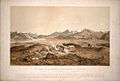
"The Chain of the Kuenlúen, from Súmgal, in Turkistán (Lat North 36° 8', Long. East of Green. 78° 5', Height 13, 215 Engl. feet)" by Hermann Schlagintweit, August 1856. Lithographed by Sabatier, printed in oil-colours by Lemereier, Paris. The Hindu-tagh Pass is the break in the mountains on the right.
-
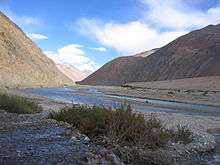
Karakash River in the Western Kunlun Range, seen from the Xinjiang-Tibet Highway
-
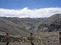
View of Western Kunlun Range from the Xinjiang-Tibet Highway
Maps
-

A lower-resolution 1909 Map of the Princely State of Kashmir and Jammu. Sumgal at the base of the Hindu-tagh Pass, Chinese Turkestan, is shown in the top right corner.
-
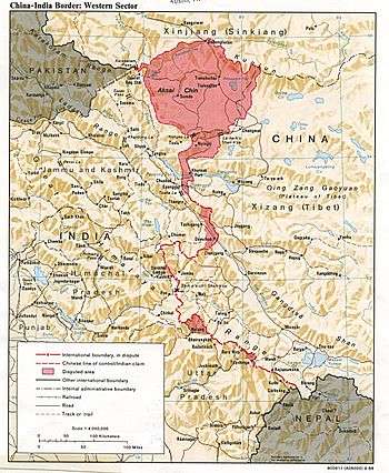
US State Department Map of Aksai Chin. Hindutash is just north of the town of Kangxiwar, Xinjiang shown at the top of the map, north of Aksai Chin.
-
Map of Aurel Stein (1911) based on that of the Survey of India showing the "Hindutash Dawan" in the Kunlun Mountains in Chinese Turkestan
Notes
- 1 2 (Trotter 1878, p. U8)
- ↑ Xinjiang Uyghur Autonomous Region Road Atlas (中国分省公路丛书:新疆维吾尔自治区), published by 星球地图出版社 Xingqiu Ditu Chubanshe, 2008, ISBN 978-7-80212-469-1. Map of Hotan Prefecture, pp. 18-19.
See also
References
- Johnson, W. H. (1867), "Report on His Journey to Ilchí, the Capital of Khotan, in Chinese Tartary", Journal of the Royal Geographical Society of London, 37 (1): 1–47.
- Schlagintweit, Hermann; Schlagintweit, Adolphe; Schlagintweit, Robert (1861), Results of a Scientific Mission to India and High Asia: undertaken between the years MDCCCLIV and MDCCCLVIII, Leipzig/London: F. A. Brockhaus/Trubner and Co..
- Stein, M. Aurel (1909), "Explorations in Central Asia, 1906-8", The Geographical Journal, 34 (1): 5–36, doi:10.2307/1777985.
- Stein, M. Aurel (1911), "Note on Maps Illustrating Dr. Stein's Explorations in Chinese Turkestan and Kansu", The Geographical Journal, 37 (3): 275–280, doi:10.2307/1777400.
- Trotter, H. (1878), "On the Geographical Results of the Mission to Kashghar, under Sir T. Douglas Forsyth in 1873-74", Journal of the Royal Geographical Society of London, 48 (2): 173–234.