Hinton Blewett
| Hinton Blewett | |
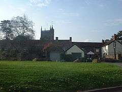 Pub and church tower at Hinton Blewett |
|
 Hinton Blewett |
|
| Population | 308 (2011)[1] |
|---|---|
| OS grid reference | ST593568 |
| Unitary authority | Bath and North East Somerset |
| Ceremonial county | Somerset |
| Region | South West |
| Country | England |
| Sovereign state | United Kingdom |
| Post town | BRISTOL |
| Postcode district | BS39 5 |
| Dialling code | 01761 |
| Police | Avon and Somerset |
| Fire | Avon |
| Ambulance | South Western |
| EU Parliament | South West England |
| UK Parliament | North East Somerset |
Coordinates: 51°18′32″N 2°35′00″W / 51.3088°N 2.5832°W
Hinton Blewett is a village and civil parish in Somerset, England. It is situated 5 miles (8.0 km) north of Wells, 15 miles (24.1 km) south of Bristol on the northern slope of the Mendip Hills within the designated Area of Outstanding Natural Beauty (AONB) and in the Chew Valley near to the source of the River Chew. The parish has a population of 308.[1]
History
The village was known in the Domesday Book as Hantone, the Blewett part of the name coming from the Bluet family in the fourteenth century.[2] Hantone is believed to mean 'A poor enclosure' from the Old English hean and tun.[3]
The parish was part of the hundred of Chewton.[4]
The name of the village is sometimes spelled as Hinton Blewitt. There is a village green outside the pub and church, sometimes known as the "Barbary".[2]
William Rees-Mogg took the title of Baron Rees-Mogg, of Hinton Blewett, when he was made a life peer in 1988, although in 1998 he and his family moved to nearby Mells. Lord Rees-Mogg's children Jacob and Annunziata spent much of their childhood in the village.
Governance
The parish council has responsibility for local issues, including setting an annual precept (local rate) to cover the council’s operating costs and producing annual accounts for public scrutiny. The parish council evaluates local planning applications and works with the local police, unitary council officers, and neighbourhood watch groups on matters of crime, security, and traffic. The parish council's role also includes initiating projects for the maintenance and repair of parish facilities, such as the village hall or community centre, playing fields and playgrounds, as well as being consulted by the unitary council on the maintenance, repair, and improvement of highways, drainage, footpaths, public transport, and street cleaning. Conservation matters (including trees and listed buildings) and environmental issues are also of interest to the council.
Along with East and West Harptree, Hinton Blewett is part of the Mendip Ward, which is represented by one councillor on the unitary authority of Bath and North East Somerset, created in 1996, responsible for almost all local government functions, including local planning and building control, education, social services, libraries, main roads, public transport, trading standards, waste disposal, strategic planning, council housing, environmental health, markets and fairs, refuse collection, recycling, cemeteries, crematoria, leisure services, parks, and tourism. Fire, police, and ambulance services are provided by the Avon Fire and Rescue Service, the Avon and Somerset Constabulary, and the South Western Ambulance Service.
Between 1 April 1974 and 1 April 1996, Hinton Blewett was in the Wansdyke district of the county of Avon,[5] and before 1974 was part of the Clutton Rural District of Somerset.[6]
The parish is represented in the House of Commons as part of North East Somerset, which elects one Member of Parliament, and is also part of the South West England constituency of the European Parliament which elects seven MEPs.
Demographics
According to the 2001 Census, the Mendip Ward (which includes East and West Harptree), had 1,465 residents, living in 548 households, with an average age of 39.0 years. Of these 79% of residents describing their health as 'good', 22% of 16- to 74-year-olds had no qualifications; and the area had an unemployment rate of 1.5% of all economically active people aged 16–74. In the Index of Multiple Deprivation 2004, it was ranked at 25,387 out of 32,482 wards in England, where 1 was the most deprived LSOA and 32,482 the least deprived.[7]
Buildings
Church
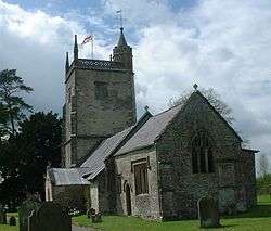
The Church of St Margaret is largely built of Blue Lias with Doulting Stone arcade,[8] and probably dates from the 13th century although parts are as late as the 16th or 17th century. The five bells were cast in 1708 by the Bilbies of Chew Stoke.[2] It includes the coat of arms of Simon Seward (Rector 1514–59) over the doorway. The church is a Grade I listed building Historic England. "Church of St Margaret (32823)". Images of England.
Grade II listed buildings
- Historic England. "Middle Road Farmhouse (32828)". Images of England.
- Historic England. "K6 Telephone Kiosk (32852)". Images of England.
- Historic England. "Coley House (32827)". Images of England.
- Historic England. "The Manor House Farmhouse (32824)". Images of England.
- Historic England. "The Old Rectory (32825)". Images of England.
- Historic England. "West House Farmhouse (32826)". Images of England.
References
- 1 2 "Hinton Blewett Parish". Neighbourhood Statistics. Office for National Statistics. Retrieved 31 December 2013.
- 1 2 3 Mason, Edmund J.; Mason, Doreen (1982). Avon Villages. Robert Hale Ltd. ISBN 978-0-7091-9585-6.
- ↑ Robinson, Stephen (1992). Somerset Place Names. Wimborne, Dorset: The Dovecote Press Ltd. ISBN 1-874336-03-2.
- ↑ "Somerset Hundreds". GENUKI. Retrieved 8 October 2011.
- ↑ "The Avon (Structural Change) Order 1995". HMSO. Retrieved 9 December 2007.
- ↑ "Clutton RD". A vision of Britain Through Time. University of Portsmouth. Retrieved 4 January 2014.
- ↑ "Neighbourhood Statistics LSOA Bath and North East Somerset 021D Mendip". Office for National Statistics 2001 Census. Retrieved 25 April 2006.
- ↑ Pevsner, Nikolaus (1958). The Buildings of England: North Somerset and Bristol. Penguin Books. ISBN 978-0-14-071013-7.
External links
| Wikimedia Commons has media related to Hinton Blewett. |
- "Area 6 - Hinton Blewett and Newton St Loe Plateau Lands". BANES Environmental Services. Retrieved 5 October 2010.
- Map of Hinton Blewitt circa 1900