Hitterdalen
| Hitterdalen | |
|---|---|
| Village | |
|
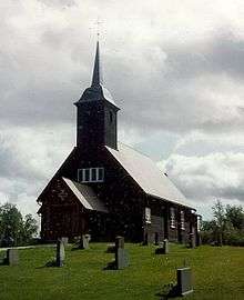
View of the chapel in the village | |
 Hitterdalen  Hitterdalen Location in Sør-Trøndelag | |
| Coordinates: 62°36′35″N 11°38′12″E / 62.60972°N 11.63667°ECoordinates: 62°36′35″N 11°38′12″E / 62.60972°N 11.63667°E | |
| Country | Norway |
| Region | Trøndelag |
| County | Sør-Trøndelag |
| District | Gauldalen |
| Municipality | Røros |
| Elevation[1] | 727 m (2,385 ft) |
| Time zone | CET (UTC+01:00) |
| • Summer (DST) | CEST (UTC+02:00) |
| Post Code | 7374 Røros |
Hitterdalen is a village in the municipality of Røros in Sør-Trøndelag county, Norway. The village is located on the road between Røros and Brekken, about half way between the two places. It sits about 3 kilometres (1.9 mi) south of the lake Aursund.
Hitterdal Chapel is located in the village.
References
- ↑ "Hitterdalen" (in Norwegian). yr.no. Retrieved 2011-02-18.
This article is issued from Wikipedia - version of the 8/5/2016. The text is available under the Creative Commons Attribution/Share Alike but additional terms may apply for the media files.