Hochsauerlandkreis
| Hochsauerlandkreis | |
|---|---|
| District | |
 | |
| Country |
|
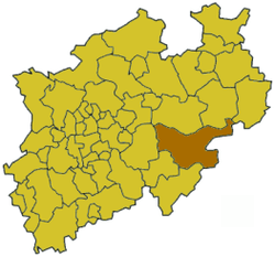
| State | North Rhine-Westphalia |
| Adm. region | Arnsberg |
| Capital | Meschede |
| Area | |
| • Total | 1,958.71 km2 (756.26 sq mi) |
| Population (31 December 2015)[1] | |
| • Total | 263,762 |
| • Density | 130/km2 (350/sq mi) |
| Time zone | CET (UTC+1) |
| • Summer (DST) | CEST (UTC+2) |
| Vehicle registration | HSK |
| Website | http://www.hochsauerlandkreis.de |
Hochsauerlandkreis (meaning “High Sauerland District” in German) is a Kreis (district) in the east of North Rhine-Westphalia, Germany. Neighboring districts are Soest, Paderborn, Höxter, Waldeck-Frankenberg, Siegen-Wittgenstein, Olpe, Märkischer Kreis.
The district is named “High Sauerland” because two of the highest mountains of the Sauerland, Langenberg and Kahler Asten are in its territory. With 2,766 (Langenberg) and 2,762 ft (Kahler Asten) these are also the highest mountains of North Rhine-Westphalia.
History
The district was established in 1975 in the reorganization of the districts in North Rhine-Westphalia by merging the previous districts Arnsberg, Brilon and Meschede.
Geography
Geographically the district covers a big part of the Sauerland mountains, including the highest and third highest elevation – the Langenberg near Olsberg with 843 m, and the better known Kahler Asten with 842 m near Winterberg. These are also the two highest mountains of North Rhine-Westphalia.
Coat of arms
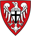 |
The coat of arms was inherited from the former district Arnsberg. It shows the eagle as the symbol of the Earls of Arnsberg. When their county lost independence in 1368 it fell to the bishops of Cologne, thus the sign on the breast of the eagle shows the Cologne cross. |
Towns and municipalities
| Towns | Municipalities | |
|---|---|---|
|
|
|
Town twinnings
Hochsauerland is twinned with the following cities:
Notable persons
- Franz Hoffmeister (died 1943), Roman Catholic priest
Notable places
- Abbey Bergkloster, Bestwig [2]
- Abbey Grafschaft, Schmallenberg
- Abbey Königsmünster, Meschede [3]
References
- ↑ "Amtliche Bevölkerungszahlen". Landesbetrieb Information und Technik NRW (in German). 18 July 2016.
- ↑ Herzlich willkommen Bergkloster Bestwig im Hochsauerlandkreis/Nordrhein-Westfalen
- ↑ Anfahrt mit der Bahn
External links
![]() Media related to Hochsauerlandkreis at Wikimedia Commons
Media related to Hochsauerlandkreis at Wikimedia Commons
- Official website (German)
- Touristic website (German)

Coordinates: 51°15′N 8°20′E / 51.25°N 8.33°E