Hodge Beck
| Hodge Beck | |
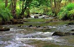 Hodge Beck in Kirkdale | |
| Country | England |
|---|---|
| Counties | North Yorkshire |
| Mouth | |
| - location | River Dove |
| - coordinates | 54°14′18″N 0°55′51″W / 54.2384°N 0.9309°WCoordinates: 54°14′18″N 0°55′51″W / 54.2384°N 0.9309°W |
| Length | 23 km (14 mi) |
| Basin | 58 km2 (22 sq mi) |
| Discharge | for Cherry Farm |
| - average | 0.67 m3/s (24 cu ft/s) |
Hodge Beck is a beck that flows through the North York Moors national park in North Yorkshire, England. It is an upper tributary of the River Dove which it joins near Welburn south of Kirkbymoorside. The beck is 14 miles (23 km) long and has a total catchment area of 58 square kilometres (22 sq mi).[1][2][3]
Course
The beck rises on the flanks of Round Hill in the Cleveland Hills of the North York Moors and flows south through Bransdale, to reach Cockayne where it is joined by its first tributary called Bloworth Slack.[3] It continues south to meet Ouse Gill, another of its tributaries before it flows through Sleightholme Dale and then Kirkdale where it is forded by a minor road.[3] The beck often runs dry at this point in the summer months as it disappears into the local limestone bedrock. Near the Kirkdale ford, is the prehistoric Kirkdale Cave, where the fossilised remains of Pleistocene megafauna were found.[4] On leaving Kirkdale, it is bridged by the A170, and the original A road crossing at Tilehouse Bridge, near Welburn, where it passes Welburn Hall. It then continues past the Slingsby Aviation airstrip, before reaching the River Dove.[3]
Hydrology
The flow of the beck has been measured, in its upper and middle reaches since 1936. The upper gauge at Bransdale, was closed in the 1970s, where it recorded an average flow of 0.35 cubic metres per second (12 cu ft/s). It was replaced by a second gauging station at Cherry Farm in Sleightholme Dale, where the record from 1974 shows that the catchment of 37 square kilometres (14 sq mi) to the gauging station yielded an average flow of 0.67 cubic metres per second (24 cu ft/s).[5] The beck has a natural flow regime, unaffected by direct artificial influences.[6] The highest river level recorded at the station occurred on the 19 June 2005, with a height of 2.55 metres (8 ft 4 in) and an estimated flow of 80 cubic metres per second (2,800 cu ft/s).[6]
The catchment upstream of the station has an average annual rainfall of 947 millimetres (37.3 in) and a maximum altitude of 451 metres (1,480 ft) on Round Hill at the source of the beck.[7] Land use within the basin is mainly rural, consisting of moorland and grassland with some woodland.[7]
See also
References
- ↑ "Hodge Beck". Geoview. Retrieved 15 May 2016.
- ↑ "Hodge Beck". Geoview. Retrieved 15 May 2016.
- 1 2 3 4 "Hodge Beck from Source to River Dove". Catchment Data Explorer. Environment Agency. Retrieved 15 May 2016.
- ↑ "Kirkdale". ormerod.uk. Retrieved 15 May 2016.
- ↑ "27054 - Hodge Beck at Cherry Farm Daily Flow Data". National Rivers Flow Archive. Centre for Ecology & Hydrology. Retrieved 15 May 2016.
- 1 2 "27054 - Hodge Beck at Cherry Farm Info". National Rivers Flow Archive. Centre for Ecology & Hydrology. Retrieved 15 May 2016.
- 1 2 "27054 - Hodge Beck at Cherry Farm Catchment Info". National Rivers Flow Archive. Centre for Ecology & Hydrology. Retrieved 15 May 2016.
External links
| Wikimedia Commons has media related to Hodge Beck. |