Holhol
| Holhol حلحول | |
|---|---|
| Town | |
 | |
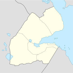 Holhol Location in Djibouti | |
| Coordinates: 11°19′N 42°56′E / 11.317°N 42.933°E | |
| Country |
|
| Region | Ali Sabieh |
| Area | |
| • Total | 0.40 km2 (0.15 sq mi) |
| Elevation | 470 m (1,540 ft) |
| Population | |
| • Total | 3,519 |
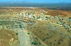
Holhol is a town in the Ali Sabieh Region of Djibouti. It is located 52km south-west of the capital Djibouti City, at an altitude of 470m.
Overview

Holhol is served by a station on the meter gauge Ethio-Djibouti Railway. A notable feature of the meter-gauge railway is a viaduct, 29 meters high and 45 meters long, that was built in 1900. The station is a transit point for commercial goods from Ethiopia. Holhol also has a station on the new standard gauge Addis Ababa–Djibouti Railway.
The town also lies along National Highway 5. It is the seventh largest city in the country.
Additionally, Holhol has a number of primary and secondary schools as well as nurseries. The El-Hajj Hassan Gouled Military Academy is located here. One kilometer from the town is the local college. Nearby towns and villages include Ali Sabieh (31 km), Goubetto (18 km) and Ali Adde (24 km).
Demographics
As of 2012, the population of Holhol has been estimated to be 3,519. The city inhabitants belong to various mainly Afro-Asiatic-speaking ethnic groups, with the Issa Somali predominant.
Climate
Holhol is located in the central Ali Sabieh Region. In winter, there is much more rainfall in the town than during the summer. The hottest month of the year is July, when the average high temperature is 102°F (39°C). The average annual temperature in the city is 27.6 °C. Around 195 mm of precipitation falls annually.[1]
| Climate data for Holhol | |||||||||||||
|---|---|---|---|---|---|---|---|---|---|---|---|---|---|
| Month | Jan | Feb | Mar | Apr | May | Jun | Jul | Aug | Sep | Oct | Nov | Dec | Year |
| Average high °C (°F) | 25.0 (77) |
26.3 (79.3) |
28.5 (83.3) |
31.0 (87.8) |
34.3 (93.7) |
38.2 (100.8) |
39.1 (102.4) |
37.9 (100.2) |
35.6 (96.1) |
31.6 (88.9) |
28.0 (82.4) |
26.8 (80.2) |
31.86 (89.34) |
| Average low °C (°F) | 17.5 (63.5) |
19.3 (66.7) |
20.1 (68.2) |
23.0 (73.4) |
25.8 (78.4) |
29.0 (84.2) |
27.8 (82) |
27.2 (81) |
27.5 (81.5) |
22.8 (73) |
20.0 (68) |
18.2 (64.8) |
23.18 (73.72) |
| Average precipitation mm (inches) | 5 (0.2) |
9 (0.35) |
24 (0.94) |
37 (1.46) |
16 (0.63) |
7 (0.28) |
10 (0.39) |
32 (1.26) |
29 (1.14) |
13 (0.51) |
7 (0.28) |
6 (0.24) |
195 (7.68) |
| Source: Climate-Data.org, altitude: 443m[1] | |||||||||||||
Sister towns
See also
References
- 1 2 "Climate: Holhol - Climate graph, Temperature graph, Climate table". Climate-Data.org. Retrieved 25 September 2013.
Coordinates: 11°19′N 42°56′E / 11.317°N 42.933°E