Homalin Township
| Homalin Township ဟုမ္မလင်း မြို့နယ် | |
|---|---|
| Township | |
|
Satellite view. The long strip is Homalin Airport. The meandering Uyu river can be seen joining the Chindwin river south of the town. | |
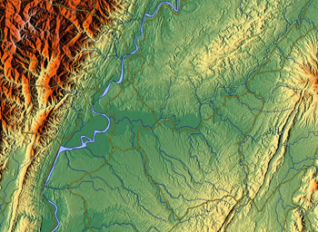
 Township highlighted in the Sagaing Region | |
 Homalin Township Location in Burma | |
| Coordinates: 24°53′N 94°55′E / 24.883°N 94.917°ECoordinates: 24°53′N 94°55′E / 24.883°N 94.917°E | |
| Country |
|
| Region | Sagaing Region |
| District | Hkamti District |
| Capital | Homalin |
| Time zone | MST (UTC+6.30) |
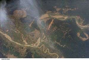
Homalin Township (Burmese: ဟုမ္မလင်း မြို့နယ် [hóʊɴməlɪ́ɴ mjo̰nɛ̀]) is a township in Hkamti District in the Sagaing Region of Burma. The principal town is Homalin.[1] The principal rivers flowing through the township are the Chindwin River form north to south and the Uyu River from east to west, joining the Chindwin near Homalin town.[2]
History
Gardens were first planted along the banks of the Chindwu in Homalin Township around 1700. Several villages such as Tamanthi, Maungkan, Tason, Kawya, Onbet, Maingwe and Malin have been documented as producing pickled tea, known as "laphet".[3]
The 1908 Imperial Gazetteer of India recorded that the steamers of the Irrawaddy Flotilla Company plied weekly between Pakokku and Homalin. Government of Myanmar also plied its launches on this route.[4][5] During World War II, Homalin on the bank of the Chindwin River, was occupied by the Japanese in late May/early June 1944.[6] Following this, after the Japanese were defeated, the town was combed thoroughly to remove any Japanese soldiers and this was followed by further preparations to counter any Japanese gunboat attacks from the river side.[7]
Naga tribes and their subgroups of Angkul, Nauk-aw, Laing Nang, Hyein Myay, Pain Kuu, Para, Makuri, Smmara, Pon Myo and Kyan Naga live in Homalin Township, apart from other townships such as the Khamti Township, Lahe Township, Layshee Township, Tanai Township, Nan Yon Township and Pan Saung of Sagaing Division.[8]
Wildlife
The Tamanthi Wildlife Sanctuary, which was established on April 11, 1974 on the eastern bank of the Chindwin River, forms part of Hkamti and Homalin Townships in Hkamti District of Sagaing Division. The area covered under this sanctuary is 830.40 square miles (2,150.7 km2), bounded between the Uyu River and Chindwin River; 230.40 square miles (596.7 km2) of this area is under the jurisdiction of the Homalin Township, while 600 square miles (1,600 km2) of the sanctuary is under Khamti Township. The sanctuary abounds in tigers, elephants, gaur (Asiatic bison), leopards, serow, bear, Sumatran rhinoceros (Didermocherus Sumatrensis) and Javan rhinoceros (Rhinoceros sondaicus). In the past, it was a favourite ground for wildlife hunters and poachers. It is also reported to be home for Were-tigers known in Europe as the European werewolf. Other fauna found here are the White-winged wood duck and Masked Fin foot.[9] Over all, 30 species of mammals, including the endangered species of Roofed turtle are found here.[10]
Towns and villages
Awthaw, Awthaw, Chaunggan, Chaungson, Chaungzon, Dokthida, Gwedaukkon, Gwegyi, Gwegyi, Gyobin, Hehkam, Hepet, Hkodaung, Hkomi, Hkonsa, Hmangin, Hmawyonmyaing, Homalin, Hpacheleik, Hpanaing, Htawng-u, Htedanshi, Htingu, Htonmalut, Hulaung, Hunawng, Hunawng, Hupet, Hwebalan, Hwein, Hwekyin, Hwemate, Hwena, Hwepanan, Ingyintha, Intha, Kadaungbwin, Kanbawng, Kaukngo, Kawngkan, Kawngkan, Kawngkankyun, Kawya, Kettha, Kodaungma, Kondan, Kondan, Kondan, Kuntawng, Kwenan, Kyaingkyaing, Kyaukkwe, Kyawngon, Kyebin, Kyizu, Kyun-u, Lawngmin, Lawngpawng, Letagawng, Letpantha, Letsaunggan, Magyibin, Maingdaung, Maingkaing, Maingwe, Makaukpat, Mala, Malin, Malon, Manawtha, Man Huna, Man Kin, Manlinta, Manmaw, Man Maw, Man Maw, Manpa, Mansein, Mansein, Manthe, Man Thet, Mantonhe, Masein, Maungkan, Meng-u, Metkalet, Mezali, Minbwe, Minyagon, Molin, Mongkun, Mong Tawng, Monkali, Myaingtha, Myaukkon, Myauk-ywa, Myene, Myenga, Myintha, Namalin, Namamo, Namaw, Namchaw, Namheinkaw, Namhka, Namhkam, Namhkansi, Namhon, Namhpanwaik, Namhta, Namkut, Namlit, Nammaw, Nammonggwe, Nammu, Nammun, Nampagan, Nampahok, Nampangon, Nampethka, Namponbon, Nampwehlaing, Namset, Namtalan, Namtaungkyin, Na-nauk, Nankaung, Nansabi, Nantat, Nanthabaik, Nanthanyit, Na-ta-kyaik, Nathe, Natnan, Naunghto-ngo, Naungkatiat, Naungmon, Naungpin, Naungpin, Naungtaw, Naungyin, Nawngbamu, Nawnghena, Nawnghkam, Nawnghkun, Nawngkauk, Nawngke, Nawnglun, Nawngmawn, Nawngpang, Nawngpat, Nawngpu-awng, Nawngpuse, Nawngsankyin, Nawngsansaing, Nawngse, Nawngshu, Nawngtaw, Ngauksa, Ngobin, Nonpala, Nwenaing, Nyaungbintha, Nyaunggon, Obokadauk, Onbet, Onbinhin, Padaung, Pahok, Pamalon, Pamun, Panghkok, Panghpahpa, Panghta, Pangshwehlaw, Paukka, Paybin, Payit, Pebin, Pegon, Pehkwin, Peinhnegon, Petkala, Pinma, Pinnoksut, Pinpalu, Poktho, Saguzwe, Sahpe, Saingkun, Saingkyu, Saingme, Sankat, Sankyein, Satkaya, Sauksaik, Sawpaga, Sayetkon, Sedaw, Shwedwin, Shwetagun, Sinlamaung, Sinnga, Sitsawk, Sutle, Swekawngaw, Tabaw, Taikat, Talaunggyaung, Tamanthi, Tapan, Tape, Tason, Tatkon, Taungbola, Taungdaw, Taungni-chinywa, Taung-ywa, Tawngbohla, Tawnglin, Tawng-ywa, Tawzi, Teinkin, Teinmata, Tetkon, Thabigon, Thapangaing, Thapanzeik, Thaungdut, Thawun, Thayagon, Thayagon, Thetkedawng, Thitseikkon, Thugyizu, Tilawng, Tonbawdi, Tonhe, Tonleik, Tonlon, Tonlonhupang, Tonmahe, Tonmakeng, Tonmalaw, Tonmate, Tonmatet, Tonmenan, Tonpin, Tonsaga, Tonsahka, Tonzi, Twetwa, Twetwa, Wetka, Yalagaung, Yaza, Yebawmi, Yegyanzin, Yegyaw, Yele, Yele, Yethpa, Ywadanshe, Ywathit, Zedizeik, Zibyugon.
Languages
Festivals
The most famous festival celebrated in the Homalin Township, which is largely inhabited by Naga tribals is the Kaibi New Year festival on 15 January every year, which is fact is a festival common to all Naga tribals of the entire region. Several other festivals by the community are the new housing ceremony, harvesting ceremony and the spiritual worship ceremony.[8]
References
- ↑ "Myanmar States/Divisions & Townships Overview Map" Myanmar Information Management Unit (MIMU)
- ↑ "Map of Homalin Township"
- ↑ Kew bulletin. 10. Royal Botanic Gardens, Kew, JSTOR (Organization), H. M. Stationery Office. 1896. p. 14.
- ↑ Imperial gazetteer of India: provincial series. 11. Superintendent of Government Printing. 1908. p. 229. Retrieved 2010-09-28.
- ↑ Sir William Stevenson Meyer (1908). Imperial Gazetteer of India. 10. Clarendon Press. p. 248.
- ↑ Bisheshwar Prasad. The reconquest of Burma, June 1942 - August 1945. Official history of the Indian Armed Forces in the Second World War, 1939-1945. p. 54.
- ↑ Commager, Henry Steele (2004). The Story of the Second World War. Brassey's. p. 214. ISBN 1-57488-741-6. Retrieved 2010-09-28.
- 1 2 "Ethnic Tribes in Myanmar (Burma)". The Naga Tribes. Ethnic Tours in Myanmar. Archived from the original on December 10, 2006. Retrieved 2010-09-30.
- ↑ Sein Tu. "The Nature of Were-Tigers". Tamanthi Wild-life Sanctuary. Department of Psychology, University of Mandalay. Retrieved 2009-09-28.
- ↑ "Htamanthie wildlife sanctuary (Homalin Township, Sagaing Division)". Myanmar Walker. Retrieved 2010-09-28.
External links
- Maplandia World Gazetteer - map showing the township boundary
Capital: Sagaing | ||
| Hkamti District |   | |
| Kale District | ||
| Katha District | ||
| Mawlaik District | ||
| Monywa District | ||
| Sagaing District | ||
| Shwebo District | ||
| Tamu District | ||
| Yinmabin District | ||
| Naga Self-Administered Zone | ||