Honey Prairie Fire
| Honey Prairie Fire | |
|---|---|
|
Satellite image of the Honey Prairie Fire. | |
| Location | Okefenokee Swamp, Georgia |
| Coordinates | 30°43′48″N 82°22′08″W / 30.73°N 82.369°W |
| Statistics[1] | |
| Date(s) | April 30, 2011 – April 16, 2012 |
| Burned area | 309,200 acres (1,251 km2) |
| Cause | Lightning |
| Map | |
 | |
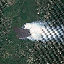
The Honey Prairie Fire was a 2011 wildfire that burned 309,200 acres (1,251 km2) of primarily scrub and brush in the Okefenokee Swamp are of southern Georgia.[2] Because fire restores the prairie ecosystem, fire managers in the Okefenokee National Wildlife Refuge allowed the fire to burn. Fire fighters worked to preserve structures and keep the fire within the refuge rather than contain the flames.[2]
Lightning started the fire on April 28, and by 6 p.m. on May 8, about 61,822 acres (250.18 km2) had burned.[2] By the time the fire was officially declared out on April 16, 2012, it had burned a total of 309,200 acres (1,251 km2).[3]
References
- ↑ "InciWeb: Honey Prairie Complex". InciWeb. Retrieved 14 October 2016.
- 1 2 3 "Honey Prairie Fire, Georgia". NASA.
- ↑ "Honey Prairie Fire Declared Out" (PDF). United States Fish and Wildlife Service. April 17, 2012. Retrieved June 6, 2013.
This article is issued from Wikipedia - version of the 10/14/2016. The text is available under the Creative Commons Attribution/Share Alike but additional terms may apply for the media files.