Horseshoe Pass
| Horseshoe Pass | |
|---|---|
| Welsh: Bwlch yr Oernant | |
 | |
| Elevation | 417 m (1,368 ft) |
| Location | Denbighshire, north-east Wales |
| Coordinates | 53°00′49″N 3°12′58″W / 53.0135°N 3.2162°WCoordinates: 53°00′49″N 3°12′58″W / 53.0135°N 3.2162°W |
The Horseshoe Pass (Welsh: Bwlch yr Oernant, "Pass of the Cold Stream") is a mountain pass in Denbighshire, north-east Wales. It separates Llantysilio Mountain to the west from the 565 metre (1,854 feet) mountain and Marilyn Cyrn-y-Brain to the east. The A542 road from Llandegla to Llangollen runs through the pass, reaching a maximum height of 417 metres (1,368 ft). The road travels in a horseshoe shape around the sides of a valley, giving the pass its name.
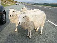
This route dates from 1811, when a turnpike road was constructed across the area. As with the rest of the roads in the Clwydian Range, it is not uncommon for sheep to gather in the road, sometimes causing problems for drivers. The road is also frequently closed in winter due to snowfall or landslides.
The Pass is well known for the Ponderosa cafe at its highest point and the scenic views along the road. Both the cafe and the pass itself are extremely popular with cyclists & motorcyclists. There are many walks and routes in the immediate area that are popular with hikers, and there are a number of campsites nearby.
References
- Llandegla Millennium Action Group (2003) Llandegla Then and Now, LMAG, Llandegla.
September 2005
External links
- Historic Landscape Characterisation - The Vale of Llangollen: Maesyrychen, Clwyd-Powys Archaeological Trust
- Horseshoe Pass walk, BBC
- HorseShoe Pass Denbighshire, Positively North Wales