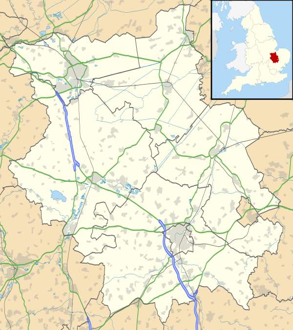
Houghton, Cambridgeshire
| Houghton | |
 Houghton |
|
| Population | 2,559 (2001) 1,817 (2011) |
|---|---|
| OS grid reference | TL281724 |
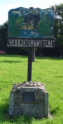
| Civil parish | Houghton and Wyton |
| District | Huntingdonshire |
| Shire county | Cambridgeshire |
| Region | East |
| Country | England |
| Sovereign state | United Kingdom |
| Post town | HUNTINGDON |
| Postcode district | PE28 |
| Dialling code | 01480 |
| Police | Cambridgeshire |
| Fire | Cambridgeshire |
| Ambulance | East of England |
| EU Parliament | East of England |
| UK Parliament | Huntingdon |
|
|
Coordinates: 52°20′06″N 0°07′08″W / 52.335°N 0.119°W
Houghton /ˈhoʊtən/ is a village in Cambridgeshire, England.[1] Houghton lies approximately 3 miles (5 km) east of Huntingdon on the A1123 road, and not far south of RAF Wyton. It lies on the north bank of the River Great Ouse, where Houghton Mill is located.
Houghton is in the civil parish of Houghton and Wyton . Houghton is situated within Huntingdonshire which is a non-metropolitan district of Cambridgeshire as well as being a historic county of England. Houghton was named one of the "Best Places to Live in the east" by The Sunday Times in 2016.
History
Houghton is mentioned in the Domesday Book and described as "Hoctune".
It has had a number of serious floods.
There used to be an old piece of film footage taken by the Houghton Scout group of the village.
The first RAF sortie of the second world war was flown out of RAF Wyton.
Government
Houghton is part of the civil parish of Houghton and Wyton, which has a parish council. The parish council is elected by the residents of the parish who have registered on the electoral roll; the parish council is the lowest tier of government in England.
A parish council is responsible for providing and maintaining a variety of local services including allotments and a cemetery; grass cutting and tree planting within public open spaces such as a village green or playing fields. The parish council reviews all planning applications that might affect the parish and makes recommendations to Huntingdonshire District Council, which is the local planning authority for the parish. The parish council also represents the views of the parish on issues such as local transport, policing and the environment. The parish council raises its own tax to pay for these services, known as the parish precept, which is collected as part of the Council Tax. The parish council has nine councillors and meets approximately every two weeks through the year.[2]
Houghton was in the historic and administrative county of Huntingdonshire until 1965. From 1965, the village was part of the new administrative county of Huntingdon and Peterborough. Then in 1974, following the Local Government Act 1972, Houghton became a part of the county of Cambridgeshire.
The second tier of local government is Huntingdonshire District Council which is a non-metropolitan district of Cambridgeshire and has its headquarters in Huntingdon. Huntingdonshire District Council has 52 councillors representing 29 district wards.[3] Huntingdonshire District Council collects the council tax, and provides services such as building regulations, local planning, environmental health, leisure and tourism.[4] Houghton is a part of the district ward of The Hemingfords and is represented on the district council by two councillors.[5][3] District councillors serve for four-year terms following elections to Huntingdonshire District Council.
For Houghton the highest tier of local government is Cambridgeshire County Council which has administration buildings in Cambridge. The county council provides county-wide services such as major road infrastructure, fire and rescue, education, social services, libraries and heritage services.[6] Cambridgeshire County Council consists of 69 councillors representing 60 electoral divisions.[7] Houghton is part of the electoral division of The Hemingfords and Fen Stanton[5] and is represented on the county council by one councillor.[7]
At Westminster Houghton is in the parliamentary constituency of Huntingdon,[5] and elects one Member of Parliament (MP) by the first past the post system of election. Houghton is represented in the House of Commons by Jonathan Djanogly (Conservative). Jonathan Djanogly has represented the constituency since 2001. The previous member of parliament was John Major (Conservative) who represented the constituency between 1983 and 2001. For the European Parliament Houghton is part of the East of England constituency which elects seven MEPs using the d'Hondt method of party-list proportional representation.
Demography
Population
In the period 1801 to 1901 the population of the separate parishes of Houghton and Wyton was recorded every ten years by the UK census. During this time the population was in the range of 467 (the lowest was in 1901) and 818 (the highest was in 1871).[8]
From 1901, a census was taken every ten years with the exception of 1941 (due to the Second World War).
| Parish |
1911 |
1921 |
1931 |
1951 |
1961 |
1971 |
1981 |
1991 |
2001 |
2011 |
|---|---|---|---|---|---|---|---|---|---|---|
| Houghton | 350 | 315 | 321 | |||||||
| Wyton | 169 | 323 | 445 | |||||||
| Houghton and Wyton | 519 | 638 | 766 | 2437 | 2908 | 4114 | 3699 | 3363 | 2559 | 1817 |
All population census figures from report Historic Census figures Cambridgeshire to 2011 by Cambridgeshire Insight.[8]
The separate parishes of Houghton and Wyton were combined into a single parish between 1931 and 1951.
In 2011, the parish covered an area of 1,623 acres (657 hectares)[8] and so the population density of Houghton and Wyton in 2011 was 716.5 persons per square mile (276.6 per square kilometre).
Notable buildings
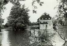
Houghton Mill is an old watermill owned by the National Trust that is still used for demonstrating flour milling.

Houghton's parish Anglican church dates from the Norman era. It is dedicated to St Mary. It now serves as the church for the combined parish of Houghton and Wyton. Near the church sits a former United Reform Church chapel that has been converted into a residential retreat centre.
Other Places of interest
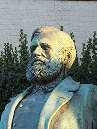
At the centre of the village is an area known as the village green, although it is completely paved. The centrepiece of the green is a thatched clock tower. Adjacent to the tower is a monumental bust of former village resident Potto Brown (1797–1871), a miller and nonconformist philanthropist. Also on the green are an old water pump and a traditional Red telephone box.
It is possible to walk from Houghton to Hemingford Abbots across the flood meadows, and to St Ives along the Thicket Path. There is a nature reserve (Wildlife Trust) along the Thicket Path known as Houghton Meadows ("Far Close") that shows markings of traditional ridge and furrow farming.
In the village centre there is a War memorial hall.
On Houghton Hill there is a cemetery.
There used to be two veterinary poultry research centres, one on Houghton Hill and the other in "The Elms".
There are a number of old houses of interest, particularly in the village green and near the playing field. The playing field is used for football, tennis and cricket. On the field there is a bowling club, cricket pavilion, tennis courts, football pitch and a scout hut.
At the village green is the former home of artist Charles Whymper (1853–1941). He was a relative of Edward Whymper who led the first ascent of the Matterhorn, in which members of the team (including schoolboy Douglas Hadow died during the descent under what some consider controversial circumstances. A model of the mountain is in the garden and just visible from the green.
The disused railway line runs through Houghton near the river.
Feast week
Every summer (normally the first fortnight of July) there is a week of community events, entitled "feast week". This has included a fun run, fayre and other sporting and fancy dress events.
Education
The only school in the village is Houghton Primary School for children aged five to eleven. The school straddles the boundary between Houghton and Wyton. Children from the school normally feed into St Peters school, Huntingdon, although some pupils go to St Ivo school, Hinchingbrooke school, or Ramsey Abbey school.
Notable residents and people associated with Houghton

- Potto Brown (1797–1871), miller and philanthropist
- Claud Vernon Burder[9]
- George Christopher Burder MC (died 17 April 1945 in Germany) formerly of Wyton Rectory and son of Revd. Claud Vernon Burder and Mary Gabrielle Fielding Burder.[10] He has been described by the Torenmuseum De Peperbus museum in Geffen, Netherlands as the 'hero of Geffen'[11]
- Lee Coombs, DJ and composer
- Charles Whymper (1853–1941), artist
- John Leslie Green of the Royal Army Medical Corps (and attached to 1/5th Battalion the Sherwood Foresters), who was one of the nine VCs of the First Day of the Somme during the First World War[12]
- John Galbraith Graham, crossword compiler and former minister at St Mary's Church, Houghton
- David McCandless, author (attended Houghton primary school)
See also
References
- ↑ Ordnance Survey: Landranger map sheet 153 Bedford & Huntingdon (St Neots & Biggleswade) (Map). Ordnance Survey. 2013. ISBN 9780319231722.
- ↑ "Houghton and Wyton Parish Council: Parish Councillors". www.houghtonwytonpc.co.uk. Houghton and Wyton Parish Council. Retrieved 7 February 2016.
- 1 2 "Huntingdonshire District Council: Councillors". www.huntingdonshire.gov.uk. Huntingdonshire District Council. Retrieved 23 February 2016.
- ↑ "Huntingdonshire District Council". www.huntingdonshire.gov.uk. Huntingdonshire District Council. Retrieved 23 February 2016.
- 1 2 3 "Ordnance Survey Election Maps". www.ordnancesurvey.co.uk. Ordnance Survey. Retrieved 23 February 2016.
- ↑ "Cambridgeshire County Council". www.cambridgeshire.gov.uk. Cambridgeshire County Council. Retrieved 23 February 2016.
- 1 2 "Cambridgeshire County Council: Councillors". www.cambridgeshire.gov.uk. Cambridgeshire County Council. Retrieved 15 February 2016.
- 1 2 3 "Historic Census figures Cambridgeshire to 2011" (xlsx – download). www.cambridgeshireinsight.org.uk. Cambridgeshire Insight. Retrieved 12 February 2016.
- ↑ <http://www.thesun.co.uk/sol/homepage/features/3063872/Heros-WW1-memoirs-found-after-91-years.html
- ↑ "Auction Wednesday 25th March 2015; Lot 614" (PDF). Dix Noonan Webb. Retrieved 8 September 2016.
- ↑ http://www.houghtonandwyton.co.uk/notices.php
- ↑ http://www.hellfire-corner.demon.co.uk/9vcs.htm