Hound Tor
| Hound Tor | |
|---|---|
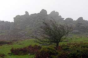 View of Hound Tor | |
| Highest point | |
| Elevation | 414 m (1,358 ft) |
| Prominence | c. 26 m |
| Coordinates | 50°35′46″N 3°46′44″W / 50.59623°N 3.77878°WCoordinates: 50°35′46″N 3°46′44″W / 50.59623°N 3.77878°W |
| Geography | |
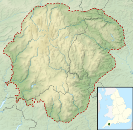 Hound Tor Location of Hound Tor in Dartmoor | |
| Location | Dartmoor, England |
| OS grid | SX742789 |
| Topo map | OS Landranger 191 |
Hound Tor is a tor on Dartmoor, Devon, England and is a good example of a heavily weathered granite outcrop. It is easily accessible, situated within a few minutes from the B3387 between Bovey Tracey and Widecombe-in-the-Moor.
The site is administered by Dartmoor National Park Authority for English Heritage as it includes the ruins of a medieval village, alongside prehistoric works of stone construction nearby.
Etymology
Sabine Baring-Gould said that it derived its name from the shape assumed by the blocks on the summit that have been weathered into forms resembling the heads of dogs peering over the natural battlements.[1]
Medieval village
To the south-east of the tor, on a north-eastern-facing slope are the remains of Hundatora, a deserted medieval village. This was built on land farmed originally in the Bronze Age and which may have been used for grazing in the Roman period. The village was excavated between 1961 and 1975. It has four Dartmoor longhouses, many with a central drainage channel, and several smaller houses and barns. These buildings date from the 13th century. The three grain storage barns appear to have been adapted to include corn dryers, indicative of the deteriorating climate. Pollen evidence indicates that farming had stopped by 1350, but recent analysis of pottery suggests that the village was probably occupied until the late 14th or early 15th century.[2]
The settlement is first mentioned in the Domesday Book as belonging to Tavistock Abbey:
Land for 4 ploughs. In Lordship 1 plough; 2 slaves; 1 virgate, 2 villages and 4 smallholders with 1 plough and 1 virgate. Meadow, 9 acres; woodland 2 acres; pasture, 1 league. 1 cattle; 28 sheep; 18 goats. Value 20 s.
The villagers apparently left little behind when they left, though the acidic soil would have destroyed much evidence; the excavations unearthed a single coin from the time of Henry III, and some broken pottery originating from Crockerton in Wiltshire.[3]
Other archaeological remains
There are a number of older remains of human occupation nearby, including a prehistoric farmstead 400 metres north-west of the settlement, and to the south are some Bronze age hut circles.
Outlines of medieval fields can still be seen, especially from vantage points on top of the tor. The fields are bounded by "corn ditches" - granite walls fronting a ditch, with earth piled up behind the wall.
Culture
According to a local legend Hound Tor was created when a pack of hounds were turned to stone (see Bowerman's Nose).
The 1975 Doctor Who story The Sontaran Experiment was shot on location at Hound Tor.
It is also thought to have inspired a number of artists and writers, such as Sir Arthur Conan Doyle in The Hound of the Baskervilles.
The tor is popular with rock climbers [4]
References
- ↑ Eric Hemery (1983). High Dartmoor. London: Robert Hale. pp. 739–740. ISBN 0-7091-8859-5.
- ↑ "Hound Tor medieval village". English Heritage. Retrieved 24 June 2015.
- ↑ Chapman, L. The Ancient Dwellings of Grimspound and Hound Tor. Orchard publishing (Newton Abbot) 1996, pp. 22-25
- ↑ http://www.ukclimbing.com/logbook/crag.php?id=224
External links
| Wikimedia Commons has media related to Hound Tor Deserted Medieval Village. |